Make a donation
Gear up for your next adventure:
As an Amazon Associate, this site earns from qualifying purchases at no extra cost to you.
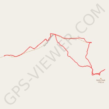
Keith Peak Loop
Loop hike to Keith Peak via East Keith Ranch Road. #Hiking #Loop #Mountain #Nature
- Distance: 4.4 mi
- Elevation gain: 1,519 ft
- Maximum elevation: 5,653 ft
- Elevation loss: 1,519 ft
- Minimum elevation: 4,432 ft
- Moving time: 2 h 27 m
- Moving speed: 1.8 mph
- Maximum speed: 3.1 mph
- Total time: 3 h 34 m
- Global speed: 1.2 mph
Interactive trail map
Make a donation
Gear up for your next adventure:
As an Amazon Associate, this site earns from qualifying purchases at no extra cost to you.
Trail profile
- Distance: 4.4 mi
- Elevation gain: 1,519 ft
- Maximum elevation: 5,653 ft
- Elevation loss: 1,519 ft
- Minimum elevation: 4,432 ft
- Moving time: 2 h 27 m
- Moving speed: 1.8 mph
- Maximum speed: 3.1 mph
- Total time: 3 h 34 m
- Global speed: 1.2 mph
Make a donation
Gear up for your next adventure:
As an Amazon Associate, this site earns from qualifying purchases at no extra cost to you.
About this trail
Name: Keith Peak Loop trail, distance, elevation, map, profile, GPS track
Start: East Keith Ranch Road, Cochise County, Arizona, United States (32.11983 -110.24476)
End: East Keith Ranch Road, Cochise County, Arizona, United States (32.11984 -110.24477)
Coordinates: 32.11590 -110.24477 32.12446 -110.22046
Topography: Cochise County topographic map, elevation, terrain
Make a donation
Gear up for your next adventure:
As an Amazon Associate, this site earns from qualifying purchases at no extra cost to you.