Thank you for supporting this site ❤️
Make a donation
Make a donation
Gear up for your next adventure:
As an Amazon Associate, this site earns from qualifying purchases at no extra cost to you.
Redwood Park Loop
Interactive trail map
Thank you for supporting this site ❤️
Make a donation
Make a donation
Gear up for your next adventure:
As an Amazon Associate, this site earns from qualifying purchases at no extra cost to you.
Trail profile
- Distance: 0.7 mi
- Elevation gain: 102 ft
- Maximum elevation: 299 ft
- Elevation loss: 102 ft
- Minimum elevation: 236 ft
Thank you for supporting this site ❤️
Make a donation
Make a donation
Gear up for your next adventure:
As an Amazon Associate, this site earns from qualifying purchases at no extra cost to you.
About this trail
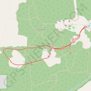
Name: Redwood Park Loop trail, distance, elevation, map, profile, GPS track
Coordinates: 49.03391 -122.73166 49.03592 -122.72501
Thank you for supporting this site ❤️
Make a donation
Make a donation
Gear up for your next adventure:
As an Amazon Associate, this site earns from qualifying purchases at no extra cost to you.
Other hiking, mountain biking, running and outdoor activity trails
Click on a trail to view its statistics, map and profile.
Tsawwassen - Chilliwack
Canada > British Columbia > Metro Vancouver Regional District
Distance: 61.4 mi • Elevation gain: 1,640 ft • Maximum elevation: 413 ft