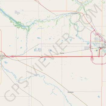
Moose Jaw - Regina
#Bike
- Distance: 44.1 mi
- Elevation gain: 384 ft
- Maximum elevation: 1,913 ft
- Elevation loss: 341 ft
- Minimum elevation: 1,798 ft
Interactive trail map
Trail profile
- Distance: 44.1 mi
- Elevation gain: 384 ft
- Maximum elevation: 1,913 ft
- Elevation loss: 341 ft
- Minimum elevation: 1,798 ft
About this trail
Name: Moose Jaw - Regina trail, distance, elevation, map, profile, GPS track
Start: Fairview, Moose Jaw, Saskatchewan, S6H 7B2, Canada (50.41060 -105.50927)
End: 2317, Albert Street, Centre Square, Regina, Saskatchewan, S4P 4K1, Canada (50.44212 -104.61731)
Coordinates: 50.38975 -105.50985 50.44241 -104.61728
Other hiking, mountain biking, running and outdoor activity trails
Click on a trail to view its statistics, map and profile.
Regina - Indian Head
Canada > Saskatchewan > Regina
#Bike #Regina #IndianHead
Distance: 44.6 mi • Elevation gain: 541 ft • Maximum elevation: 2,293 ft