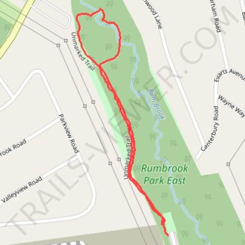
Rumbrook Park East
- Distance: 0.9 mi
- Elevation gain: 95 ft
- Maximum elevation: 292 ft
- Elevation loss: 95 ft
- Minimum elevation: 207 ft
- Moving time: 27 m 57 s
- Moving speed: 1.9 mph
- Maximum speed: 3.2 mph
- Total time: 37 m 32 s
- Global speed: 1.4 mph
Interactive trail map
Trail profile
- Distance: 0.9 mi
- Elevation gain: 95 ft
- Maximum elevation: 292 ft
- Elevation loss: 95 ft
- Minimum elevation: 207 ft
- Moving time: 27 m 57 s
- Moving speed: 1.9 mph
- Maximum speed: 3.2 mph
- Total time: 37 m 32 s
- Global speed: 1.4 mph
About this trail
Name: Rumbrook Park East trail, distance, elevation, map, profile, GPS track
Coordinates: 41.04033 -73.82200 41.04570 -73.81912
Topography: Westchester County topographic map, elevation, terrain
Other hiking, mountain biking, running and outdoor activity trails
Click on a trail to view its statistics, map and profile.