Thank you for supporting this site ❤️
Make a donation
Make a donation
Gear up for your next adventure:
As an Amazon Associate, this site earns from qualifying purchases at no extra cost to you.
Mount Alford - Carneys Creek
Interactive trail map
Thank you for supporting this site ❤️
Make a donation
Make a donation
Gear up for your next adventure:
As an Amazon Associate, this site earns from qualifying purchases at no extra cost to you.
Trail profile
- Distance: 39.1 mi
- Elevation gain: 3,684 ft
- Maximum elevation: 1,785 ft
- Elevation loss: 3,691 ft
- Minimum elevation: 390 ft
Thank you for supporting this site ❤️
Make a donation
Make a donation
Gear up for your next adventure:
As an Amazon Associate, this site earns from qualifying purchases at no extra cost to you.
About this trail
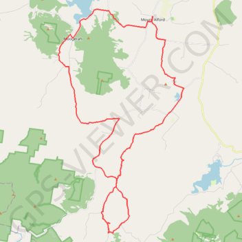
Name: Mount Alford - Carneys Creek trail, distance, elevation, map, profile, GPS track
Coordinates: -28.23406 152.51161 -28.05920 152.62311
Thank you for supporting this site ❤️
Make a donation
Make a donation
Gear up for your next adventure:
As an Amazon Associate, this site earns from qualifying purchases at no extra cost to you.
Other hiking, mountain biking, running and outdoor activity trails
Click on a trail to view its statistics, map and profile.
Mount Greville - Up waterfall gorge, summit, down palm gorge
Australia > Queensland > Moogerah
Distance: 4.4 mi • Elevation gain: 2,192 ft • Maximum elevation: 2,408 ft