Thank you for supporting this site ❤️
Make a donation
Make a donation
Gear up for your next adventure:
As an Amazon Associate, this site earns from qualifying purchases at no extra cost to you.
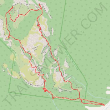
Mount Greville - Up waterfall gorge, summit, down palm gorge
- Distance: 4.4 mi
- Elevation gain: 2,192 ft
- Maximum elevation: 2,408 ft
- Elevation loss: 2,185 ft
- Minimum elevation: 571 ft
Interactive trail map
Thank you for supporting this site ❤️
Make a donation
Make a donation
Gear up for your next adventure:
As an Amazon Associate, this site earns from qualifying purchases at no extra cost to you.
Trail profile
- Distance: 4.4 mi
- Elevation gain: 2,192 ft
- Maximum elevation: 2,408 ft
- Elevation loss: 2,185 ft
- Minimum elevation: 571 ft
Thank you for supporting this site ❤️
Make a donation
Make a donation
Gear up for your next adventure:
As an Amazon Associate, this site earns from qualifying purchases at no extra cost to you.
About this trail
Name: Mount Greville - Up waterfall gorge, summit, down palm gorge trail, distance, elevation, map, profile, GPS track
Coordinates: -28.08638 152.50168 -28.07418 152.51511
Thank you for supporting this site ❤️
Make a donation
Make a donation
Gear up for your next adventure:
As an Amazon Associate, this site earns from qualifying purchases at no extra cost to you.
Other hiking, mountain biking, running and outdoor activity trails
Click on a trail to view its statistics, map and profile.