R SP900970
- Distance: 0.6 mi
- Elevation gain: 26 ft
- Maximum elevation: 167 ft
- Elevation loss: 30 ft
- Minimum elevation: 144 ft
- Moving time: 20 m 55 s
- Moving speed: 1.7 mph
- Maximum speed: 3.0 mph
- Total time: 1 h 55 m
- Global speed: 0.3 mph
Interactive trail map
Trail profile
- Distance: 0.6 mi
- Elevation gain: 26 ft
- Maximum elevation: 167 ft
- Elevation loss: 30 ft
- Minimum elevation: 144 ft
- Moving time: 20 m 55 s
- Moving speed: 1.7 mph
- Maximum speed: 3.0 mph
- Total time: 1 h 55 m
- Global speed: 0.3 mph
About this trail
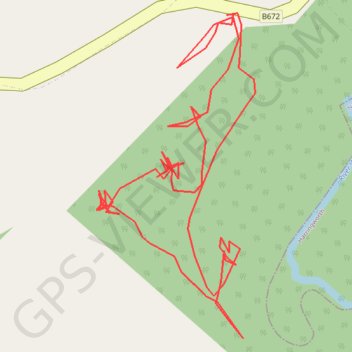
Name: R SP900970 trail, distance, elevation, map, profile, GPS track
Start: B672, Seaton, Thorpe by Water, Rutland, England, LE15 9JW, United Kingdom (52.56455 -0.67225)
End: B672, Seaton, Thorpe by Water, Rutland, England, LE15 9JW, United Kingdom (52.56455 -0.67220)
Coordinates: 52.56289 -0.67335 52.56456 -0.67201
Other hiking, mountain biking, running and outdoor activity trails
Click on a trail to view its statistics, map and profile.
The Jo Cox Way 2022 Day 3 Market Bosworth to Milton Keynes
United Kingdom > England > Leicestershire > Hinckley and Bosworth > Market Bosworth
Distance: 76.4 mi • Elevation gain: 3,127 ft • Maximum elevation: 640 ft