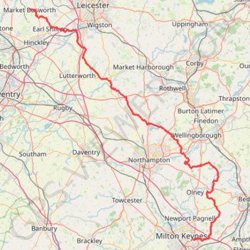
The Jo Cox Way 2022 Day 3 Market Bosworth to Milton Keynes
- Distance: 76.4 mi
- Elevation gain: 3,127 ft
- Maximum elevation: 640 ft
- Elevation loss: 3,307 ft
- Minimum elevation: 135 ft
- Moving time: 5 h 37 m
- Moving speed: 13.6 mph
- Maximum speed: 28.8 mph
- Total time: 5 h 37 m
- Global speed: 13.6 mph
Interactive trail map
Trail profile
- Distance: 76.4 mi
- Elevation gain: 3,127 ft
- Maximum elevation: 640 ft
- Elevation loss: 3,307 ft
- Minimum elevation: 135 ft
- Moving time: 5 h 37 m
- Moving speed: 13.6 mph
- Maximum speed: 28.8 mph
- Total time: 5 h 37 m
- Global speed: 13.6 mph
About this trail
Name: The Jo Cox Way 2022 Day 3 Market Bosworth to Milton Keynes trail, distance, elevation, map, profile, GPS track
Coordinates: 52.02791 -1.39915 52.62595 -0.59400
Other hiking, mountain biking, running and outdoor activity trails
Click on a trail to view its statistics, map and profile.
Loop walk along River Nene around Chester House area
United Kingdom > England > North Northamptonshire > Little Irchester
Distance: 1.1 mi • Elevation gain: 26 ft • Maximum elevation: 154 ft
Walk from Irthlingborough to Rushden Lakes in Nene Wetlands Nature Reserve
United Kingdom > England > North Northamptonshire > Wellingborough
Distance: 2.2 mi • Elevation gain: 46 ft • Maximum elevation: 141 ft
Wellingborough Waendel Walk walk
United Kingdom > England > North Northamptonshire > Wellingborough > Little Irchester
Distance: 10.1 mi • Elevation gain: 463 ft • Maximum elevation: 335 ft
42 Km walk around Wellingborough
United Kingdom > England > North Northamptonshire > Wellingborough > Little Irchester
Distance: 25.9 mi • Elevation gain: 1,010 ft • Maximum elevation: 377 ft
Walking from Kettering to Northampton via various PRoW paths
United Kingdom > England > North Northamptonshire > Kettering
Distance: 17.1 mi • Elevation gain: 876 ft • Maximum elevation: 384 ft
The Jo Cox Way 2022 Day 4 - Milton Keynes to Uxbridge
United Kingdom > England > City of Milton Keynes > Milton Keynes > Monkston
Distance: 64.9 mi • Elevation gain: 3,406 ft • Maximum elevation: 823 ft
Walk from Kettering to Corby
United Kingdom > England > North Northamptonshire > Kettering
Distance: 7.9 mi • Elevation gain: 466 ft • Maximum elevation: 397 ft
Banbury ➡️ Mollington ➡️ Cropredy ➡️ Banbury
United Kingdom > England > Oxfordshire > Cherwell District > Banbury
Distance: 13.6 mi • Elevation gain: 702 ft • Maximum elevation: 538 ft
The JCW 23 - Cranfield to Uxbridge
United Kingdom > England > Central Bedfordshire > Cranfield
Distance: 56.0 mi • Elevation gain: 2,831 ft • Maximum elevation: 873 ft
Cycling around Kettering
United Kingdom > England > North Northamptonshire > Kettering
Kettering Cycling
Distance: 22.4 mi • Elevation gain: 1,181 ft • Maximum elevation: 417 ft
Moors Lane via Houlton Way
United Kingdom > England > Warwickshire > Rugby > Clifton upon Dunsmore CP
Distance: 7.1 mi • Elevation gain: 331 ft • Maximum elevation: 361 ft
Cycle tour of Hinckley
United Kingdom > England > Leicestershire > Hinckley and Bosworth > Hinckley
cycling, hinckley
Distance: 7.6 mi • Elevation gain: 259 ft • Maximum elevation: 456 ft
Parks and Ride Stony
United Kingdom > England > City of Milton Keynes > Milton Keynes > Wolverton
Milton Keynes Cycling
Distance: 6.1 mi • Elevation gain: 167 ft • Maximum elevation: 295 ft
Kettering Half Marathon
United Kingdom > England > North Northamptonshire > Kettering
Distance: 13.1 mi • Elevation gain: 607 ft • Maximum elevation: 361 ft
Radway 🔁 Mollington
United Kingdom > England > Warwickshire > Stratford-on-Avon > Radway
Distance: 14.5 mi • Elevation gain: 1,411 ft • Maximum elevation: 715 ft
Isham Footpath
United Kingdom > England > North Northamptonshire > Kettering
Evening Run
Distance: 6.3 mi • Elevation gain: 364 ft • Maximum elevation: 282 ft
JCW25 Day 4
United Kingdom > England > Central Bedfordshire > Cranfield
Distance: 65.8 mi • Elevation gain: 3,166 ft • Maximum elevation: 873 ft
Route
United Kingdom > England > Central Bedfordshire > Upper Sundon
Distance: 70.2 mi • Elevation gain: 2,963 ft • Maximum elevation: 558 ft
R SP900970
United Kingdom > England > Rutland > Thorpe by Water
Distance: 0.6 mi • Elevation gain: 26 ft • Maximum elevation: 167 ft