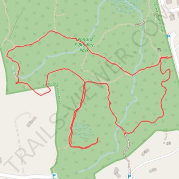
Leonard J. Bradley Park loop trails
- Distance: 1.4 mi
- Elevation gain: 69 ft
- Maximum elevation: 367 ft
- Elevation loss: 69 ft
- Minimum elevation: 312 ft
- Moving time: 36 m 58 s
- Moving speed: 2.2 mph
- Maximum speed: 5.0 mph
- Total time: 44 m 45 s
- Global speed: 1.8 mph
Interactive trail map
Trail profile
- Distance: 1.4 mi
- Elevation gain: 69 ft
- Maximum elevation: 367 ft
- Elevation loss: 69 ft
- Minimum elevation: 312 ft
- Moving time: 36 m 58 s
- Moving speed: 2.2 mph
- Maximum speed: 5.0 mph
- Total time: 44 m 45 s
- Global speed: 1.8 mph
About this trail
Name: Leonard J. Bradley Park loop trails trail, distance, elevation, map, profile, GPS track
Coordinates: 41.18015 -73.43688 41.18322 -73.43112
Topography: Western Connecticut Planning Region topographic map, elevation, terrain
Other hiking, mountain biking, running and outdoor activity trails
Click on a trail to view its statistics, map and profile.