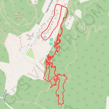
Trapp Hill
- Distance: 5.4 mi
- Elevation gain: 489 ft
- Maximum elevation: 1,322 ft
- Elevation loss: 489 ft
- Minimum elevation: 1,148 ft
- Moving time: 48 m 36 s
- Moving speed: 6.6 mph
- Maximum speed: 20.6 mph
- Total time: 1 h 4 m
- Global speed: 5.0 mph
Interactive trail map
Trail profile
- Distance: 5.4 mi
- Elevation gain: 489 ft
- Maximum elevation: 1,322 ft
- Elevation loss: 489 ft
- Minimum elevation: 1,148 ft
- Moving time: 48 m 36 s
- Moving speed: 6.6 mph
- Maximum speed: 20.6 mph
- Total time: 1 h 4 m
- Global speed: 5.0 mph
About this trail
Name: Trapp Hill trail, distance, elevation, map, profile, GPS track
Start: Balsam Drive, Stowe, Lamoille County, Vermont, 05672, United States (44.46751 -72.74149)
End: Balsam Drive, Stowe, Lamoille County, Vermont, 05672, United States (44.46750 -72.74149)
Coordinates: 44.45705 -72.74326 44.46938 -72.73869
Topography: Lamoille County topographic map, elevation, terrain
Other hiking, mountain biking, running and outdoor activity trails
Click on a trail to view its statistics, map and profile.