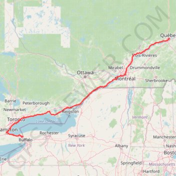
Québec - Montréal - Saint-Laurent River - Lake Ontario - Niagara Falls
Interactive trail map
Trail profile
- Distance: 670.1 mi
- Elevation gain: 15,761 ft
- Maximum elevation: 686 ft
- Elevation loss: 15,197 ft
- Minimum elevation: -3 ft
About this trail
Name: Québec - Montréal - Saint-Laurent River - Lake Ontario - Niagara Falls trail, distance, elevation, map, profile, GPS track
Coordinates: 43.08778 -79.89248 46.82520 -71.19960
Other hiking, mountain biking, running and outdoor activity trails
Click on a trail to view its statistics, map and profile.
Mount Washington Summit Loop via Tuckerman Ravine Trail and Lion Head Trail
United States > New Hampshire > Coos County
Hiking Mount Washington via the Tuckerman Ravine and Lion Head Trails offers a blend of rugged terrain and rewarding views. The route begins at Pinkham Notch Visitor Center and ascends steadily through dense forests, crossing streams and passing waterfalls like Crystal Cascades Falls before reaching the…
Distance: 8.4 mi • Elevation gain: 4,249 ft • Maximum elevation: 6,270 ft
Mount Mansfield Loop via Maple Ridge Trail, Long Trail and Sunset Ridge Trail
United States > Vermont > Chittenden County > Underhill
The Mount Mansfield Loop provides a challenging but rewarding hike to the highest peak in Vermont. As you climb, the varied terrain offers rocky paths, steep ascents, and exposed ridgelines, culminating in breathtaking panoramic views of the Champlain Valley, the Adirondacks, and the Green Mountains. The…
Distance: 8.2 mi • Elevation gain: 2,900 ft • Maximum elevation: 4,370 ft
Georgian Bay Islands National Park
Canada > Ontario > Muskoka District > Georgian Bay Township
Lake Huron. Beausoleil Island. #Hiking #Loop #Georgian #Beausoleil #Huron
Distance: 4.9 mi • Elevation gain: 200 ft • Maximum elevation: 640 ft
Cawthra Mulock Nature Reserve Loop
Canada > Ontario > York Region > King
Distance: 1.7 mi • Elevation gain: 164 ft • Maximum elevation: 817 ft
The Chin of Mount Mansfield via Sunset Ridge Trail in Underhill State Park
United States > Vermont > Chittenden County > Underhill
The Sunset Ridge Trail to the summit of Mount Mansfield provides a challenging and rewarding hiking experience, offering expansive views of Vermont’s landscape. As you ascend through dense forests and rocky stretches, the trail opens up to panoramic vistas, where you can catch sight of distant valleys and…
Distance: 6.0 mi • Elevation gain: 2,628 ft • Maximum elevation: 4,370 ft
Ottawa River Pathway
Distance: 13.4 mi • Elevation gain: 427 ft • Maximum elevation: 262 ft
Presidential Range Traverse
United States > New Hampshire > Coos County > Bowman
Starting near the northern gateway of the Presidential Range, this traverse climbs from the forests of the White Mountain National Forest to the exposed ridgeline of Mount Madison, then continues over the rugged summits of Mount Adams and Mount Jefferson, with wide views across the Great Gulf and the…
Distance: 20.1 mi • Elevation gain: 8,350 ft • Maximum elevation: 6,270 ft
Middle Sister and Mount Chocorua Loop
United States > New Hampshire > Carroll County > Albany
From the Piper Trailhead in White Mountain National Forest, this loop follows Piper Trail into the forest, turns onto Nickerson Ledge Trail, and climbs toward Carter Ledge, a quieter ridge route known for open ledges, views of Mount Chocorua, and the Three Sisters. The itinerary continues over the Three…
Distance: 8.2 mi • Elevation gain: 2,703 ft • Maximum elevation: 3,442 ft
Lake Muskoka - Lake Rosseau
Canada > Ontario > Muskoka District > Gravenhurst
#Bike
Distance: 65.6 mi • Elevation gain: 4,245 ft • Maximum elevation: 1,129 ft
Downtown Syracuse to Liverpool/Clay via Onondaga Lake Parkway and Eastern Shore Recreation Trail Bike Trip
United States > New York > Onondaga County > City of Syracuse
Distance: 10.5 mi • Elevation gain: 197 ft • Maximum elevation: 427 ft
Friday Harbour Nature Reserve
Canada > Ontario > Simcoe County > Innisfil
#Hiking #MTB #Snowshoeing #Loop #FridayHarbour
Distance: 2.9 mi • Elevation gain: 72 ft • Maximum elevation: 791 ft
Haliburton Forest
Canada > Ontario > Haliburton County > Dysart et al
#Hiking #Loop #Haliburton
Distance: 4.2 mi • Elevation gain: 194 ft • Maximum elevation: 1,368 ft
Giant Mountain and Rocky Peak Ridge
United States > New York > Essex County > Town of Keene
Starting from Chapel Pond, the route climbs the Ridge Trail through forest and exposed rock to Ridge Lookout, with early views over Chapel Pond, then reaches Giant Washbowl before linking toward the Roaring Brook Trail junction. The ascent continues over steep open slabs and long ridge sections to Giant…
Distance: 8.2 mi • Elevation gain: 4,383 ft • Maximum elevation: 4,551 ft
Mount Lafayette Loop
United States > New Hampshire > Grafton County > Lincoln
The Mount Lafayette Loop begins in Franconia Notch, at the edge of the White Mountain National Forest, and climbs away from the parkway into shaded hardwood and spruce forest. The route follows the Falling Waters side of the loop beside Walker Brook and Dry Brook, passing Stairs Falls and Cloudland Falls as…
Distance: 8.4 mi • Elevation gain: 3,734 ft • Maximum elevation: 5,190 ft
Mount Lafayette Loop via Franconia Ridge Trail in White Mountain National Forest
United States > New Hampshire > Grafton County > Lincoln
The Mount Lafayette Loop is a challenging and rewarding hike, offering some of the most stunning views in the region. Starting at the Falling Waters Trail, the hike begins with a steep ascent through the forest, passing several picturesque waterfalls. The real highlight, however, comes as you reach the…
Distance: 8.2 mi • Elevation gain: 3,668 ft • Maximum elevation: 5,190 ft
Arkon Lake Loop
Canada > Ontario > Frontenac County > South Frontenac
Frontenac Provincial Park. #Hiking #Snowshoeing #Loop #Frontenac
Distance: 6.1 mi • Elevation gain: 404 ft • Maximum elevation: 627 ft
North Tripyramid, Middle Tripyramid and South Tripyramid
United States > New Hampshire > Grafton County
Starting from the Pine Bend Brook Trailhead on the Kancamagus Highway, the route enters the White Mountain National Forest and follows Pine Bend Brook into the Sandwich Range Wilderness, moving through a quiet forested drainage below Scaur Peak and The Fool Killer. The climb then steepens toward the Tripyramid…
Distance: 9.6 mi • Elevation gain: 3,346 ft • Maximum elevation: 4,081 ft
Forest Lea Trails
Canada > Ontario > Renfrew County > Laurentian Valley
Distance: 6.7 mi • Elevation gain: 390 ft • Maximum elevation: 643 ft
Mount Tecumseh
United States > New Hampshire > Grafton County > Waterville Valley
Starting from the Waterville Valley Ski Area parking area in White Mountain National Forest, the route follows the Mount Tecumseh Trail into mixed mountain forest, staying close to the Tecumseh Brook corridor before crossing the brook and climbing away from the ski slopes. The ascent becomes rockier and more…
Distance: 4.8 mi • Elevation gain: 2,188 ft • Maximum elevation: 3,924 ft
2026-06-23_11-48_Tue
United States > New Hampshire > Hillsborough County > Goffstown > Grasmere
Distance: 43.7 mi • Elevation gain: 2,110 ft • Maximum elevation: 459 ft
Mount Redfield and Cliff Mountain
United States > New York > Essex County
Hike from Heart Lake to Mount Redfield and Cliff Mountain via Van Hoevenberg Trail, Marcy Dam, Avalanche Pass Trail, Avalanche Camp, Lake Arnold Trail, Lake Arnold, Mount Marcy Trail, Mount Redfield Trail and Cliff Mountain Trail in the High Peaks Wilderness and Adirondack Park. #Hiking #Mountain #Nature…
Distance: 18.5 mi • Elevation gain: 4,590 ft • Maximum elevation: 4,554 ft
Joker's Hill Loop
Canada > Ontario > York Region > Newmarket
Thornton Bales Conservation Area. #Hiking #Running #Loop #ThorntonBales
Distance: 1.8 mi • Elevation gain: 164 ft • Maximum elevation: 1,063 ft
Old mills to humber bay park
Distance: 7.7 mi • Elevation gain: 246 ft • Maximum elevation: 315 ft
Kingdom Campground Loop
United States > Vermont > Caledonia County > Lyndon > Egypt
Distance: 4.2 mi • Elevation gain: 495 ft • Maximum elevation: 988 ft
Cobourg - Adolphustown
Canada > Ontario > Northumberland County > Cobourg
Lake Ontario. #Bike #Cobourg #Adolphustown #Ontario
Distance: 71.0 mi • Elevation gain: 1,473 ft • Maximum elevation: 390 ft
Bruce Trail from Guelph Line
Canada > Ontario > Halton Region > Burlington
Distance: 3.3 mi • Elevation gain: 390 ft • Maximum elevation: 886 ft
Welch Mountain and Dickey Mountain via Welch-Dickey Loop Trail in White Mountain National Forest
United States > New Hampshire > Grafton County > Thornton
The Welch-Dickey Loop Trail offers a diverse hiking experience, taking hikers through scenic woodlands, rocky outcrops, and granite slabs. As you ascend to the summits of Welch and Dickey Mountains, you'll encounter expansive views of surrounding peaks, including Sandwich Mountain, Mount Weetamoo, and parts of…
Distance: 4.2 mi • Elevation gain: 1,706 ft • Maximum elevation: 2,697 ft
Biidaasige Park and Tommy Thompson Park Loop Ride
Distance: 12.7 mi • Elevation gain: 220 ft • Maximum elevation: 269 ft
Lake Niapenco Trail
Lake Niapenco. Binbrook Conservation Area. #Hiking #Running #Snowshoeing #Loop #Niapenco
Distance: 2.3 mi • Elevation gain: 79 ft • Maximum elevation: 682 ft
Little Haystack Mountain, Mount Lincoln and Mount Lafayette Loop
United States > New Hampshire > Grafton County > Lincoln
Loop hike from Franconia Notch via Falling Waters Trail, Stairs Falls, Swiftwater Falls, Cloudland Falls, Little Haystack Mountain, Franconia Ridge Trail, Mount Lincoln, Mount Lafayette, Greenleaf Trail, Greenleaf Hut and Old Bridle Path in the Franconia Notch State Park and the White Mountain National Forest.…
Distance: 8.1 mi • Elevation gain: 3,760 ft • Maximum elevation: 5,190 ft
Mount Washington, Lion Head and Tuckerman Ravine Loop
United States > New Hampshire > Coos County
Loop hike from Pinkham Notch to Mount Washington via Tuckerman Ravine Trail, Crystal Cascades Falls and Lion Head Trail in the Pinkham Notch Scenic Area, the Mount Washington State Park and the White Mountain National Forest. #Hiking #Loop #Mountain #Nature #Forest #Falls #Park
Distance: 7.8 mi • Elevation gain: 4,347 ft • Maximum elevation: 6,270 ft
Sterling Pond Trail and Top of the Notch in Mount Mansfield State Forest
United States > Vermont > Lamoille County > Cambridge
The Sterling Pond Trail offers an engaging hike through a varied landscape. Along the way, hikers are treated to a rich diversity of plant life, especially as they pass into the cool, high-elevation spruce-fir forests. At Sterling Pond itself, the scenery is spectacular, with expansive views across the water…
Distance: 2.5 mi • Elevation gain: 932 ft • Maximum elevation: 3,045 ft
Bilberry Creek Ravine Loop
#Hiking #Snowshoeing #Running #Loop
Distance: 1.2 mi • Elevation gain: 43 ft • Maximum elevation: 289 ft
Upper Terrace Trails
Canada > Ontario > Renfrew County > Petawawa
Distance: 1.8 mi • Elevation gain: 75 ft • Maximum elevation: 509 ft
Downtown Toronto Walk
Distance: 2.7 mi • Elevation gain: 459 ft • Maximum elevation: 374 ft
Mount Marcy, Mount Skylight and Gray Peak
United States > New York > Essex County > Town of Keene
Return hike from Mount Marcy to Heart Lake via Mount Marcy Trail, Schofield Cobble, Four Corners, Skylight Trail, Lake Tear of the Clouds, Gray Peak Trail, Van Hoevenberg Trail, Indian Falls and Marcy Dam Pond in the High Peaks Wilderness and the Adirondack Park. #Hiking #Mountain #Nature #Forest #Lake #Falls…
Distance: 11.1 mi • Elevation gain: 1,991 ft • Maximum elevation: 5,289 ft
Round Top - Sutton Trail
Canada > Quebec > Brome-Missisquoi > Sutton
Sutton Natural Environment Park. #Hiking #Snowshoeing #Sutton
Distance: 3.8 mi • Elevation gain: 1,385 ft • Maximum elevation: 3,097 ft
Rockway Conservation Area Loop Hike
Canada > Ontario > Niagara Region > Lincoln
Distance: 4.3 mi • Elevation gain: 495 ft • Maximum elevation: 492 ft
Stoney Creek Loop
Stoney Creek Conservation Area. #Hiking #MTB #Running #Snowshoeing #Loop #StoneyCreek
Distance: 2.4 mi • Elevation gain: 62 ft • Maximum elevation: 381 ft
Mount Passaconaway and Mount Whiteface Loop
United States > New Hampshire > Carroll County > Ferncroft
Loop hike from Ferncroft to Mount Passaconaway via Ferncroft Road, Squirrel Bridge Road, Blueberry Ledge Trail, Rollins Trail, Dicey's Mill Trail, View Spur and Walden Trail in the Sandwich Range Wilderness, the Bowl Research Natural Area and the White Mountain National Forest. #Hiking #Loop #Mountain #Forest…
Distance: 11.7 mi • Elevation gain: 4,140 ft • Maximum elevation: 4,022 ft
Ottawa - Grenville-sur-la-Rouge
Canada > Ontario > (Old) Ottawa
Ottawa River. #Bike #Ottawa #GrenvilleSurLaRouge
Distance: 58.1 mi • Elevation gain: 1,083 ft • Maximum elevation: 240 ft
Mount Passaconaway and Mount Whiteface loop via Blueberry Ledge and Dicey's Mill trails
United States > New Hampshire > Carroll County > Ferncroft
Distance: 11.9 mi • Elevation gain: 3,944 ft • Maximum elevation: 4,022 ft
Scarborough - Cobourg
Lake Ontario. #Bike #Scarborough #Cobourg #Toronto #Ontario
Distance: 66.7 mi • Elevation gain: 2,352 ft • Maximum elevation: 427 ft
Stowe Pinnacle Trail via Pinnacle Meadow in C.C. Putnam State Forest
United States > Vermont > Lamoille County > Stowe
The Stowe Pinnacle Trail is a moderately challenging hike offering beautiful views of Vermont's Green Mountains. As hikers ascend through dense forests, the route rewards with striking vistas of Mount Mansfield, Camel's Hump, and the Worcester Range from the summit's rocky outcrop. The last stretch becomes…
Distance: 3.4 mi • Elevation gain: 1,047 ft • Maximum elevation: 2,569 ft
Mount Hancock via Hancock Notch Trail and Hancock Loop Trail
United States > New Hampshire > Grafton County > Lincoln
The hike to Mount Hancock, Middle Hancock and South Hancock is a scenic journey through the White Mountain National Forest, offering lush forests and rewarding viewpoints. The initial stretch along the Hancock Notch Trail is a gentle introduction with stream crossings and serene woodlands, transitioning into…
Distance: 9.2 mi • Elevation gain: 2,549 ft • Maximum elevation: 4,357 ft
Mount Washington Loop via Nelson Crag Trail, Lion Head and Crystal Cascades Falls
United States > New Hampshire > Coos County
This Mount Washington loop provides a rigorous yet rewarding adventure with diverse landscapes. Starting with a gentle forest walk on Old Jackson Road, the route quickly escalates into rockier terrain, with Nelson Crag offering panoramic views of the Presidential Range. As hikers descend via Lion Head, they…
Distance: 9.6 mi • Elevation gain: 4,449 ft • Maximum elevation: 6,270 ft
Brampton - Scarborough
Canada > Ontario > Peel Region > Brampton
Lake Ontario. #Bike #Brampton #Scarborough #Toronto #Ontario
Distance: 45.5 mi • Elevation gain: 1,870 ft • Maximum elevation: 604 ft
Burlington - Hamilton
Canada > Ontario > Halton Region > Burlington
Waterfront Trail. Lake Ontario. #Bike #Waterfront #Ontario
Distance: 7.5 mi • Elevation gain: 164 ft • Maximum elevation: 269 ft
East Hawkesbury - Montréal
Canada > Ontario > Prescott and Russell Counties > East Hawkesbury
#Bike #EastHawkesbury #Montréal
Distance: 56.8 mi • Elevation gain: 1,289 ft • Maximum elevation: 299 ft
Brockville - Lancaster
Canada > Ontario > Brockville > Brockville
Saint-Laurent River. #Bike #SaintLaurent
Distance: 84.1 mi • Elevation gain: 1,604 ft • Maximum elevation: 331 ft
Toronto - Oshawa
Canada > Ontario > Old Toronto
#Bike
Distance: 41.8 mi • Elevation gain: 1,499 ft • Maximum elevation: 600 ft
Mount Major Trail and Brook Trail Loop in Major Mountain State Forest
United States > New Hampshire > Belknap County > Alton > Mount Major
The Mount Major Trail and Brook Trail Loop offers an enjoyable and scenic hike suitable for most skill levels. The route features breathtaking panoramic views of Lake Winnipesaukee and the White Mountains from the summit, with opportunities to admire the lush forest, rocky outcroppings, and interesting…
Distance: 4.1 mi • Elevation gain: 1,129 ft • Maximum elevation: 1,768 ft
Brockville - Ottawa
Canada > Ontario > Brockville > Brockville
#Bike #Brockville #Ottawa
Distance: 73.6 mi • Elevation gain: 1,230 ft • Maximum elevation: 440 ft
Mount Pisgah via South Trail and Pulpit Rock in Willoughby State Forest
United States > Vermont > Orleans County > Westmore
The hike to Mount Pisgah is a rewarding journey with iconic views. As you ascend, Pulpit Rock provides a dramatic viewpoint perched hundreds of feet above the stunning Lake Willoughby, framed by the rugged cliffs of nearby Mount Hor. The summit reveals panoramic vistas that stretch across the Northeast…
Distance: 4.6 mi • Elevation gain: 2,329 ft • Maximum elevation: 2,726 ft
Lonesome Lake Loop Trail in Franconia Notch State Park
United States > New Hampshire > Grafton County > Lincoln
The Lonesome Lake Loop Trail in Franconia Notch State Park offers hikers a moderately challenging journey through diverse terrains. Starting from the Lafayette Place Campground, the trail ascends through a forested path, leading to the serene Lonesome Lake nestled amidst the towering peaks of Cannon Mountain,…
Distance: 3.1 mi • Elevation gain: 1,014 ft • Maximum elevation: 2,756 ft
Camel's Hump Loop via Forest City Trail, Long Trail and Burrows Trail
United States > Vermont > Chittenden County > Huntington
The Camel’s Hump Loop offers hikers a rewarding climb through dense forests, rugged alpine terrain, and open summit views. Starting on the Forest City Trail, hikers pass remnants of a Civilian Conservation Corps camp before joining the Long Trail, where views open up to showcase Vermont’s high peaks, the…
Distance: 5.6 mi • Elevation gain: 2,293 ft • Maximum elevation: 4,012 ft
Round Top and Spruce Lake Loop
Canada > Quebec > Brome-Missisquoi > Sutton
Sutton Natural Environment Park. #Hiking #Snowshoeing #Loop #Sutton
Distance: 4.4 mi • Elevation gain: 1,404 ft • Maximum elevation: 3,097 ft
Mattawa - Stonecliffe
Canada > Ontario > Nipissing District > Mattawa
Distance: 45.8 mi • Elevation gain: 2,963 ft • Maximum elevation: 1,043 ft
Salaberry-de-Valleyfield - Montréal
Canada > Quebec > Beauharnois-Salaberry > Salaberry-de-Valleyfield
#Bike
Distance: 55.9 mi • Elevation gain: 1,191 ft • Maximum elevation: 230 ft
Lye Brook Falls Trail in Green Mountain National Forest
United States > Vermont > Bennington County > Manchester Center > Manchester
The Lye Brook Falls Trail in Vermont provides a refreshing, immersive experience in the Green Mountain National Forest. The hike is mostly through a tranquil forest of hardwoods, with seasonal variations enhancing the scenery, from wildflowers in spring to vibrant fall colors. Along the way, you'll cross…
Distance: 4.5 mi • Elevation gain: 1,014 ft • Maximum elevation: 1,654 ft
Mount Adams and Mount Madison Loop
United States > New Hampshire > Coos County > Randolph
Loop hike from Appalachia Trailhead to Mount Adams and Mount Madison via Airline Trail, Gulfside Trail, Madison Spring Hut, Osgood Trail, Watson Path and Valley Way in the Whites Mountains National Forest. #Hiking #Loop #Mountain #Nature #Forest
Distance: 8.5 mi • Elevation gain: 4,957 ft • Maximum elevation: 5,755 ft
Farewell Creek Evening Walk
Canada > Ontario > Durham Region > Courtice
Distance: 3.1 mi • Elevation gain: 98 ft • Maximum elevation: 446 ft
Mount Moosilauke Loop via South Peak in White Mountain National Forest
United States > New Hampshire > Grafton County > Woodstock
The Mount Moosilauke Loop offers a rewarding hiking experience with diverse terrains and stunning views throughout the journey. Hikers will traverse rocky paths through dense forest, with occasional views opening up to alpine landscapes as they approach the summit. At the top, panoramic vistas stretch across…
Distance: 7.4 mi • Elevation gain: 2,398 ft • Maximum elevation: 4,783 ft