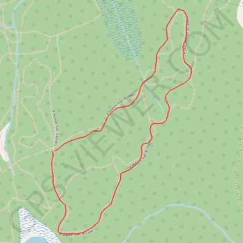
4 Season Trail: B Loop
- Distance: 1.7 mi
- Elevation gain: 194 ft
- Maximum elevation: 515 ft
- Elevation loss: 194 ft
- Minimum elevation: 400 ft
- Moving time: 24 m 15 s
- Moving speed: 4.1 mph
- Maximum speed: 15.4 mph
- Total time: 27 m 1 s
- Global speed: 3.7 mph
Interactive trail map
Trail profile
- Distance: 1.7 mi
- Elevation gain: 194 ft
- Maximum elevation: 515 ft
- Elevation loss: 194 ft
- Minimum elevation: 400 ft
- Moving time: 24 m 15 s
- Moving speed: 4.1 mph
- Maximum speed: 15.4 mph
- Total time: 27 m 1 s
- Global speed: 3.7 mph
About this trail
Name: 4 Season Trail: B Loop trail, distance, elevation, map, profile, GPS track
Coordinates: 46.07313 -77.46183 46.08207 -77.45382
Other hiking, mountain biking, running and outdoor activity trails
Click on a trail to view its statistics, map and profile.