Mam Tor
- Distance: 7.0 mi
- Elevation gain: 1,768 ft
- Maximum elevation: 1,663 ft
- Elevation loss: 1,742 ft
- Minimum elevation: 607 ft
- Moving time: 3 h 5 m
- Moving speed: 2.3 mph
- Maximum speed: 6.0 mph
- Total time: 4 h 30 m
- Global speed: 1.5 mph
Interactive trail map
Trail profile
- Distance: 7.0 mi
- Elevation gain: 1,768 ft
- Maximum elevation: 1,663 ft
- Elevation loss: 1,742 ft
- Minimum elevation: 607 ft
- Moving time: 3 h 5 m
- Moving speed: 2.3 mph
- Maximum speed: 6.0 mph
- Total time: 4 h 30 m
- Global speed: 1.5 mph
About this trail
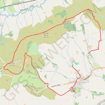
Name: Mam Tor trail, distance, elevation, map, profile, GPS track
Coordinates: 53.33907 -1.81364 53.36488 -1.76500
Other hiking, mountain biking, running and outdoor activity trails
Click on a trail to view its statistics, map and profile.
Peak District hike
United Kingdom > England > Derbyshire > High Peak > Edale > Grindsbrook Booth
Distance: 32.3 mi • Elevation gain: 4,347 ft • Maximum elevation: 2,064 ft
Peak District loop hike
United Kingdom > England > Derbyshire > High Peak > Hope
Distance: 22.6 mi • Elevation gain: 2,776 ft • Maximum elevation: 2,073 ft
Castleton and Cave Dale
United Kingdom > England > Derbyshire > High Peak > Castleton
Castleton evening wander
Distance: 3.0 mi • Elevation gain: 472 ft • Maximum elevation: 843 ft