Make a donation
Gear up for your next adventure:
As an Amazon Associate, this site earns from qualifying purchases at no extra cost to you.
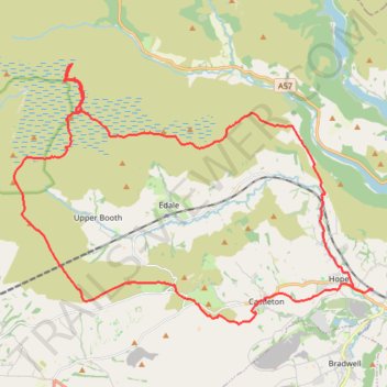
Peak District loop hike
- Distance: 22.6 mi
- Elevation gain: 2,776 ft
- Maximum elevation: 2,073 ft
- Elevation loss: 2,746 ft
- Minimum elevation: 531 ft
- Moving time: 7 h 44 m
- Moving speed: 2.9 mph
- Maximum speed: 6.8 mph
- Total time: 21 h 48 m
- Global speed: 1.0 mph
Interactive trail map
Make a donation
Gear up for your next adventure:
As an Amazon Associate, this site earns from qualifying purchases at no extra cost to you.
Trail profile
- Distance: 22.6 mi
- Elevation gain: 2,776 ft
- Maximum elevation: 2,073 ft
- Elevation loss: 2,746 ft
- Minimum elevation: 531 ft
- Moving time: 7 h 44 m
- Moving speed: 2.9 mph
- Maximum speed: 6.8 mph
- Total time: 21 h 48 m
- Global speed: 1.0 mph
Make a donation
Gear up for your next adventure:
As an Amazon Associate, this site earns from qualifying purchases at no extra cost to you.
About this trail
Name: Peak District loop hike trail, distance, elevation, map, profile, GPS track
Coordinates: 53.33715 -1.88195 53.40380 -1.72912
Make a donation
Gear up for your next adventure:
As an Amazon Associate, this site earns from qualifying purchases at no extra cost to you.
Other hiking, mountain biking, running and outdoor activity trails
Click on a trail to view its statistics, map and profile.
Peak District hike
United Kingdom > England > Derbyshire > High Peak > Edale > Grindsbrook Booth
Distance: 32.3 mi • Elevation gain: 4,347 ft • Maximum elevation: 2,064 ft
Derwent Reservoir
United Kingdom > England > Derbyshire > High Peak
Distance: 8.7 mi • Elevation gain: 1,407 ft • Maximum elevation: 1,732 ft
Castleton and Cave Dale
United Kingdom > England > Derbyshire > High Peak > Castleton
Castleton evening wander
Distance: 3.0 mi • Elevation gain: 472 ft • Maximum elevation: 843 ft
Hope to Win Hill
United Kingdom > England > Derbyshire > High Peak > Hope
Distance: 4.3 mi • Elevation gain: 932 ft • Maximum elevation: 1,467 ft
Make a donation
Gear up for your next adventure:
As an Amazon Associate, this site earns from qualifying purchases at no extra cost to you.
N 171887 3
United Kingdom > England > Derbyshire > High Peak
Distance: 2.2 mi • Elevation gain: 492 ft • Maximum elevation: 1,135 ft
Mam Tor
United Kingdom > England > Derbyshire > High Peak > Castleton
Distance: 7.0 mi • Elevation gain: 1,768 ft • Maximum elevation: 1,663 ft