Make a donation
Gear up for your next adventure:
As an Amazon Associate, this site earns from qualifying purchases at no extra cost to you.
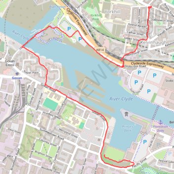
Govan-Partick Bridge
- Distance: 2.4 mi
- Elevation gain: 121 ft
- Maximum elevation: 89 ft
- Elevation loss: 52 ft
- Minimum elevation: 7 ft
- Moving time: 45 m 47 s
- Moving speed: 3.1 mph
- Maximum speed: 5.5 mph
- Total time: 45 m 47 s
- Global speed: 3.1 mph
Interactive trail map
Make a donation
Gear up for your next adventure:
As an Amazon Associate, this site earns from qualifying purchases at no extra cost to you.
Trail profile
- Distance: 2.4 mi
- Elevation gain: 121 ft
- Maximum elevation: 89 ft
- Elevation loss: 52 ft
- Minimum elevation: 7 ft
- Moving time: 45 m 47 s
- Moving speed: 3.1 mph
- Maximum speed: 5.5 mph
- Total time: 45 m 47 s
- Global speed: 3.1 mph
Make a donation
Gear up for your next adventure:
As an Amazon Associate, this site earns from qualifying purchases at no extra cost to you.
About this trail
Name: Govan-Partick Bridge trail, distance, elevation, map, profile, GPS track
Coordinates: 55.85528 -4.30989 55.86724 -4.29274
Make a donation
Gear up for your next adventure:
As an Amazon Associate, this site earns from qualifying purchases at no extra cost to you.
Other hiking, mountain biking, running and outdoor activity trails
Click on a trail to view its statistics, map and profile.
Johnstone, Scotland to Paisley via Glasgow
United Kingdom > Scotland > Renfrewshire > Johnstone
Bike
Distance: 40.5 mi • Elevation gain: 1,503 ft • Maximum elevation: 174 ft
Critical Mass Glasgow
United Kingdom > Scotland > Glasgow City > Glasgow
Bike
Distance: 12.4 mi • Elevation gain: 492 ft • Maximum elevation: 121 ft