Make a donation
Gear up for your next adventure:
As an Amazon Associate, this site earns from qualifying purchases at no extra cost to you.
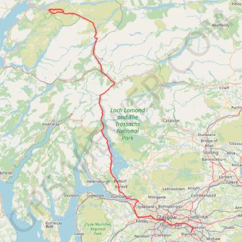
Munro hillwalk Meall Dearg Sgorr nam Fiannaidh Aonach Eagach
Interactive trail map
Make a donation
Gear up for your next adventure:
As an Amazon Associate, this site earns from qualifying purchases at no extra cost to you.
Trail profile
- Distance: 107.8 mi
- Elevation gain: 9,564 ft
- Maximum elevation: 3,156 ft
- Elevation loss: 10,026 ft
- Minimum elevation: 0 ft
Make a donation
Gear up for your next adventure:
As an Amazon Associate, this site earns from qualifying purchases at no extra cost to you.
About this trail
Name: Munro hillwalk Meall Dearg Sgorr nam Fiannaidh Aonach Eagach trail, distance, elevation, map, profile, GPS track
Start: A82, Highland, Scotland, PH50 4RL, United Kingdom (56.66661 -4.98214)
Coordinates: 55.79780 -5.08355 56.68145 -4.06083
Make a donation
Gear up for your next adventure:
As an Amazon Associate, this site earns from qualifying purchases at no extra cost to you.
Other hiking, mountain biking, running and outdoor activity trails
Click on a trail to view its statistics, map and profile.
Loop Walk at Mugdock Country Park
United Kingdom > Scotland > Stirling > Mugdock
Distance: 1.6 mi • Elevation gain: 115 ft • Maximum elevation: 564 ft
Roads and trails in Clydebank and Drumchapel
United Kingdom > Scotland > Glasgow City > Glasgow
Distance: 7.2 mi • Elevation gain: 318 ft • Maximum elevation: 151 ft
Tracked with OSMTracker for Android™
United Kingdom > Scotland > Stirling > Blanefield > Craigallian
Distance: 0.7 mi • Elevation gain: 49 ft • Maximum elevation: 584 ft
2026-06-26_10-27_Fri
United Kingdom > Scotland > Stirling > Blanefield > Craigallian
Distance: 0.7 mi • Elevation gain: 49 ft • Maximum elevation: 584 ft
Make a donation
Gear up for your next adventure:
As an Amazon Associate, this site earns from qualifying purchases at no extra cost to you.
Dumgoyne Loop Trail
United Kingdom > Scotland > Stirling > Dumgoyne
Distance: 3.2 mi • Elevation gain: 1,293 ft • Maximum elevation: 1,342 ft
Jaw Reservoir, Cochno Hill and Greenside Reservoir in Kilpatrick Hills
United Kingdom > Scotland > West Dunbartonshire > Faifley
Distance: 5.9 mi • Elevation gain: 906 ft • Maximum elevation: 1,122 ft
Trails and roads in Drumchapel
United Kingdom > Scotland > East Dunbartonshire > Glasgow
Distance: 3.4 mi • Elevation gain: 240 ft • Maximum elevation: 167 ft
The Slacks Loop Trail in Kilpatrick Hills
United Kingdom > Scotland > West Dunbartonshire > Old Kilpatrick
Distance: 5.4 mi • Elevation gain: 1,161 ft • Maximum elevation: 1,178 ft
Make a donation
Gear up for your next adventure:
As an Amazon Associate, this site earns from qualifying purchases at no extra cost to you.
Conic Hill
United Kingdom > Scotland > Stirling > Balmaha > Arrochymore
Distance: 4.2 mi • Elevation gain: 1,204 ft • Maximum elevation: 1,152 ft
West Highland Way between Milngavie and Craigallian Loch
United Kingdom > Scotland > East Dunbartonshire > Milngavie
Distance: 4.6 mi • Elevation gain: 272 ft • Maximum elevation: 384 ft
Cochno Loch and Hill - Kilpatrick Hills
United Kingdom > Scotland > West Dunbartonshire > Faifley > Cochno
Distance: 3.9 mi • Elevation gain: 673 ft • Maximum elevation: 1,089 ft
Balloch Castle Country Park
United Kingdom > Scotland > West Dunbartonshire > Balloch
Distance: 2.0 mi • Elevation gain: 108 ft • Maximum elevation: 66 ft
Make a donation
Gear up for your next adventure:
As an Amazon Associate, this site earns from qualifying purchases at no extra cost to you.
Fairlie to Largs Walk
United Kingdom > Scotland > North Ayrshire > Fairlie
Clyde Muirshiel Regional Park
Distance: 5.7 mi • Elevation gain: 154 ft • Maximum elevation: 52 ft
Trails around Drumchapel
United Kingdom > Scotland > Glasgow City > Glasgow
Distance: 2.4 mi • Elevation gain: 223 ft • Maximum elevation: 259 ft
Trails in and around Mugdock Country Park
United Kingdom > Scotland > Stirling > Mugdock
Distance: 2.3 mi • Elevation gain: 279 ft • Maximum elevation: 535 ft
Loop Walk from St Fillans to Jerusalem in Glen Tarken
United Kingdom > Scotland > Perth and Kinross > St Fillans
Distance: 3.8 mi • Elevation gain: 650 ft • Maximum elevation: 774 ft
Make a donation
Gear up for your next adventure:
As an Amazon Associate, this site earns from qualifying purchases at no extra cost to you.
Munro hillwalk - Ben Starav, Munro tops, Meall Cruidh, Stob an Duine Ruaidh
United Kingdom > Scotland > Highland
Distance: 11.6 mi • Elevation gain: 3,986 ft • Maximum elevation: 3,510 ft
Walking trail from Balmaha to summit of Conic Hill via West Highland Way - Slighe Taobh an Iar na Gàidhealtachd
United Kingdom > Scotland > Stirling > Balmaha > Arrochymore
Distance: 2.9 mi • Elevation gain: 1,043 ft • Maximum elevation: 1,112 ft
Dunrod Hill and Hillside Hill loop from Greenock West - Clyde Muirshiel Regional Park
United Kingdom > Scotland > Inverclyde > Greenock
Distance: 11.8 mi • Elevation gain: 1,345 ft • Maximum elevation: 955 ft
Loop Trail in and around Mugdock Country Park
United Kingdom > Scotland > East Dunbartonshire > Milngavie
Distance: 2.4 mi • Elevation gain: 299 ft • Maximum elevation: 535 ft
Make a donation
Gear up for your next adventure:
As an Amazon Associate, this site earns from qualifying purchases at no extra cost to you.
Munro Hillwalk Sgurr na h-Ulaidh Beinn Fhionnlaidh
United Kingdom > Scotland > Highland
Distance: 13.1 mi • Elevation gain: 5,659 ft • Maximum elevation: 3,222 ft
Pink Rib and descent from Beinn a Chrulaiste
United Kingdom > Scotland > Highland
Distance: 5.4 mi • Elevation gain: 1,919 ft • Maximum elevation: 2,799 ft
Johnstone, Scotland to Paisley via Glasgow
United Kingdom > Scotland > Renfrewshire > Johnstone
Bike
Distance: 40.5 mi • Elevation gain: 1,503 ft • Maximum elevation: 174 ft
West Highland Way: Milngavie to Mugdock Park
United Kingdom > Scotland > East Dunbartonshire > Glasgow
Distance: 4.3 mi • Elevation gain: 236 ft • Maximum elevation: 377 ft
Make a donation
Gear up for your next adventure:
As an Amazon Associate, this site earns from qualifying purchases at no extra cost to you.
Munro Hillwalk Ben Lomond, Loch Chon
United Kingdom > Scotland > Stirling > Kinlochard
Distance: 14.6 mi • Elevation gain: 3,763 ft • Maximum elevation: 3,114 ft
Signal Rock and Hagrid's Hut Loop
United Kingdom > Scotland > Highland
Distance: 2.3 mi • Elevation gain: 276 ft • Maximum elevation: 328 ft
Walking trails along River Kelvin to Kelvin Aqueduct
United Kingdom > Scotland > Glasgow City > Glasgow
Distance: 1.6 mi • Elevation gain: 98 ft • Maximum elevation: 131 ft
Glasgow, Scotland
United Kingdom > Scotland > Glasgow City > Glasgow
Afternoon Loop Bike Ride
Distance: 7.3 mi • Elevation gain: 492 ft • Maximum elevation: 364 ft
Make a donation
Gear up for your next adventure:
As an Amazon Associate, this site earns from qualifying purchases at no extra cost to you.
Critical Mass Glasgow Loop Bike
United Kingdom > Scotland > Glasgow City > Glasgow
Distance: 8.1 mi • Elevation gain: 243 ft • Maximum elevation: 95 ft
Munro Hillwalk Glencoe Fhada
United Kingdom > Scotland > Highland
Distance: 6.2 mi • Elevation gain: 2,549 ft • Maximum elevation: 3,035 ft
Make a donation
Gear up for your next adventure:
As an Amazon Associate, this site earns from qualifying purchases at no extra cost to you.
Pooteering around Edinchip
United Kingdom > Scotland > Stirling > Kingshouse
Walk around Edinchip
Distance: 1.8 mi • Elevation gain: 82 ft • Maximum elevation: 669 ft
Walk up Beinn Luibhean
United Kingdom > Scotland > Argyll and Bute
Distance: 3.1 mi • Elevation gain: 2,251 ft • Maximum elevation: 2,785 ft
Glasgow Queen's Park Walk
United Kingdom > Scotland > Glasgow City > Glasgow
Distance: 3.3 mi • Elevation gain: 223 ft • Maximum elevation: 217 ft
Critical Mass Glasgow
United Kingdom > Scotland > Glasgow City > Glasgow
Bike
Distance: 12.4 mi • Elevation gain: 492 ft • Maximum elevation: 121 ft
Make a donation
Gear up for your next adventure:
As an Amazon Associate, this site earns from qualifying purchases at no extra cost to you.
Critical Mass Glasgow
United Kingdom > Scotland > Glasgow City > Glasgow
Bike
Distance: 9.2 mi • Elevation gain: 335 ft • Maximum elevation: 118 ft
Govan-Partick Bridge
United Kingdom > Scotland > Glasgow City > Glasgow
Distance: 2.4 mi • Elevation gain: 121 ft • Maximum elevation: 89 ft
Doune - Buchany
United Kingdom > Scotland > Stirling > Doune
Morning Walk
Distance: 4.6 mi • Elevation gain: 449 ft • Maximum elevation: 318 ft
Castlehill Fort
United Kingdom > Scotland > East Dunbartonshire > Bearsden
Distance: 1.0 mi • Elevation gain: 98 ft • Maximum elevation: 361 ft
Make a donation
Gear up for your next adventure:
As an Amazon Associate, this site earns from qualifying purchases at no extra cost to you.
Glasgow, Scotland
United Kingdom > Scotland > Glasgow City > Glasgow
Morning Walk
Distance: 1.4 mi • Elevation gain: 89 ft • Maximum elevation: 102 ft
Cave of the Killer Rabbit of Caerbannog
United Kingdom > Scotland > Perth and Kinross > Ardtalnaig
Distance: 0.5 mi • Elevation gain: 174 ft • Maximum elevation: 784 ft
Loop walk in Mugdock County Park
United Kingdom > Scotland > Stirling > Mugdock
Distance: 2.9 mi • Elevation gain: 144 ft • Maximum elevation: 587 ft
Tower Hill Park
United Kingdom > Scotland > Inverclyde > Gourock
Distance: 0.3 mi • Elevation gain: 180 ft • Maximum elevation: 295 ft
Make a donation
Gear up for your next adventure:
As an Amazon Associate, this site earns from qualifying purchases at no extra cost to you.