Make a donation
Gear up for your next adventure:
As an Amazon Associate, this site earns from qualifying purchases at no extra cost to you.
Old Sawmill Lane
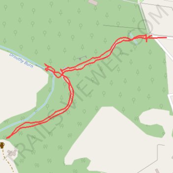
- Distance: 0.9 mi
- Elevation gain: 194 ft
- Maximum elevation: 522 ft
- Elevation loss: 187 ft
- Minimum elevation: 331 ft
- Moving time: 24 m 35 s
- Moving speed: 2.3 mph
- Maximum speed: 5.6 mph
- Total time: 36 m 52 s
- Global speed: 1.5 mph
Interactive trail map
Make a donation
Gear up for your next adventure:
As an Amazon Associate, this site earns from qualifying purchases at no extra cost to you.
Trail profile
- Distance: 0.9 mi
- Elevation gain: 194 ft
- Maximum elevation: 522 ft
- Elevation loss: 187 ft
- Minimum elevation: 331 ft
- Moving time: 24 m 35 s
- Moving speed: 2.3 mph
- Maximum speed: 5.6 mph
- Total time: 36 m 52 s
- Global speed: 1.5 mph
Make a donation
Gear up for your next adventure:
As an Amazon Associate, this site earns from qualifying purchases at no extra cost to you.
About this trail
Name: Old Sawmill Lane trail, distance, elevation, map, profile, GPS track
Start: Forneth, Perth and Kinross, Scotland, PH10 6SN, United Kingdom (56.59769 -3.47555)
End: Forneth, Perth and Kinross, Scotland, PH10 6SN, United Kingdom (56.59781 -3.47460)
Coordinates: 56.59514 -3.48232 56.59788 -3.47460
Make a donation
Gear up for your next adventure:
As an Amazon Associate, this site earns from qualifying purchases at no extra cost to you.
Other hiking, mountain biking, running and outdoor activity trails
Click on a trail to view its statistics, map and profile.
North of Loch of Clunie
United Kingdom > Scotland > Perth and Kinross > Clunie
UK, Perthshire, Clunie
Distance: 7.6 mi • Elevation gain: 853 ft • Maximum elevation: 620 ft
Around Loch Ordie
United Kingdom > Scotland > Perth and Kinross
Mountain Bike Ride, UK, Perthshire, Dunkeld
Distance: 22.3 mi • Elevation gain: 1,900 ft • Maximum elevation: 984 ft