Make a donation
Gear up for your next adventure:
As an Amazon Associate, this site earns from qualifying purchases at no extra cost to you.
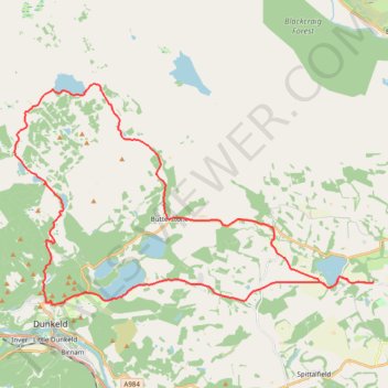
Around Loch Ordie
Mountain Bike Ride, UK, Perthshire, Dunkeld
- Distance: 22.3 mi
- Elevation gain: 1,900 ft
- Maximum elevation: 984 ft
- Elevation loss: 1,903 ft
- Minimum elevation: 171 ft
- Moving time: 2 h 9 m
- Moving speed: 10.4 mph
- Maximum speed: 25.7 mph
- Total time: 2 h 33 m
- Global speed: 8.7 mph
Interactive trail map
Make a donation
Gear up for your next adventure:
As an Amazon Associate, this site earns from qualifying purchases at no extra cost to you.
Trail profile
- Distance: 22.3 mi
- Elevation gain: 1,900 ft
- Maximum elevation: 984 ft
- Elevation loss: 1,903 ft
- Minimum elevation: 171 ft
- Moving time: 2 h 9 m
- Moving speed: 10.4 mph
- Maximum speed: 25.7 mph
- Total time: 2 h 33 m
- Global speed: 8.7 mph
Make a donation
Gear up for your next adventure:
As an Amazon Associate, this site earns from qualifying purchases at no extra cost to you.
About this trail
Name: Around Loch Ordie trail, distance, elevation, map, profile, GPS track
Coordinates: 56.57084 -3.60442 56.63241 -3.42231
Make a donation
Gear up for your next adventure:
As an Amazon Associate, this site earns from qualifying purchases at no extra cost to you.
Other hiking, mountain biking, running and outdoor activity trails
Click on a trail to view its statistics, map and profile.
The Knockie, Marlee Loch and Loch of Clunie Loop
United Kingdom > Scotland > Perth and Kinross > Craigie
Loop MTB / run / hike around Blairgowrie via The Knockie, Marlee Loch and Loch of Clunie. #Hiking #Loop #Nature #Countryside #Lake
Distance: 10.7 mi • Elevation gain: 889 ft • Maximum elevation: 666 ft
Loop Gravel Ride around Blairgowrie and Rattray between Loch of Clunie and Alyth
United Kingdom > Scotland > Perth and Kinross > Newlands
Distance: 24.7 mi • Elevation gain: 1,736 ft • Maximum elevation: 922 ft
Cally Loch Mountain Bike Ride, Dunkeld
United Kingdom > Scotland > Perth and Kinross
Distance: 24.1 mi • Elevation gain: 1,985 ft • Maximum elevation: 620 ft
Make a donation
Gear up for your next adventure:
As an Amazon Associate, this site earns from qualifying purchases at no extra cost to you.
Inchtuthil Roman Legionary Fortress
United Kingdom > Scotland > Perth and Kinross > Newlands
Inchtuthil Redoubt
Distance: 8.7 mi • Elevation gain: 427 ft • Maximum elevation: 318 ft
Falls of the Braan and River Tay loop trail
United Kingdom > Scotland > Perth and Kinross > Dunkeld > Inchmagrannachan
Distance: 6.8 mi • Elevation gain: 768 ft • Maximum elevation: 610 ft
Alyth to Spittal of Glenshee - Cateran Trail (some of)
United Kingdom > Scotland > Perth and Kinross > Alyth
Distance: 27.4 mi • Elevation gain: 3,720 ft • Maximum elevation: 2,133 ft
Make a donation
Gear up for your next adventure:
As an Amazon Associate, this site earns from qualifying purchases at no extra cost to you.
Tracks, MTB and off track sections to visit the Rocking Stone and Polney Crag
United Kingdom > Scotland > Perth and Kinross > Dunkeld > Inchmagrannachan
Distance: 2.3 mi • Elevation gain: 564 ft • Maximum elevation: 1,053 ft
Walk over A9 bridge over River Braan by pedestrian pavement (sidewalk) and small diversion for SGN gas pipeline route then Fiddlers path
United Kingdom > Scotland > Perth and Kinross > Dunkeld
Distance: 3.7 mi • Elevation gain: 259 ft • Maximum elevation: 249 ft
Spittal of Glenshee to Alyth - Some of the Cateran Trail
United Kingdom > Scotland > Perth and Kinross > Spittal of Glenshee
Distance: 23.8 mi • Elevation gain: 1,841 ft • Maximum elevation: 1,506 ft
Ninewells Kerb Cairn
United Kingdom > Scotland > Perth and Kinross
Distance: 7.2 mi • Elevation gain: 545 ft • Maximum elevation: 469 ft
Make a donation
Gear up for your next adventure:
As an Amazon Associate, this site earns from qualifying purchases at no extra cost to you.
Mountain Bike Ride Around Clunie, Perthshire
United Kingdom > Scotland > Perth and Kinross
UK, Perthshire, Clunie
Distance: 10.4 mi • Elevation gain: 1,027 ft • Maximum elevation: 689 ft
Cycle to Loch à Chait, Craigsheal and Buckinhill
United Kingdom > Scotland > Perth and Kinross > Butterstone
Distance: 8.0 mi • Elevation gain: 1,010 ft • Maximum elevation: 1,411 ft
Ninewells Kerb Cairn & Easter Cult Stones
United Kingdom > Scotland > Perth and Kinross
Around Clunie, Perthshire
Distance: 9.6 mi • Elevation gain: 922 ft • Maximum elevation: 673 ft
EMTB Gravel: Murthly - Birnam - Loop
United Kingdom > Scotland > Perth and Kinross > Newlands
Around Dunkeld, Perthshire Scotland
Distance: 28.8 mi • Elevation gain: 2,851 ft • Maximum elevation: 1,001 ft
Make a donation
Gear up for your next adventure:
As an Amazon Associate, this site earns from qualifying purchases at no extra cost to you.
Around Newtyle Hill, Dunkeld, Perthshire
United Kingdom > Scotland > Perth and Kinross
Distance: 17.5 mi • Elevation gain: 1,965 ft • Maximum elevation: 912 ft
Kinclaven Wood - Stanley - Bankfoot Loop
United Kingdom > Scotland > Perth and Kinross > Newlands
Distance: 26.7 mi • Elevation gain: 1,795 ft • Maximum elevation: 449 ft
Mountain Bike Ride Above Clunie
United Kingdom > Scotland > Perth and Kinross > Craigie
#UK #Perthshire #Clunie
Distance: 5.8 mi • Elevation gain: 620 ft • Maximum elevation: 620 ft
Around Blairgowrie, Scotland
United Kingdom > Scotland > Perth and Kinross > Craigie
UK, Perthshire, Blairgowrie
Distance: 12.2 mi • Elevation gain: 571 ft • Maximum elevation: 266 ft
Make a donation
Gear up for your next adventure:
As an Amazon Associate, this site earns from qualifying purchases at no extra cost to you.
Around Clunie, Perthshire
United Kingdom > Scotland > Perth and Kinross
Afternoon Workout. UK, Perthshire, Blairgowrie
Distance: 10.2 mi • Elevation gain: 1,014 ft • Maximum elevation: 614 ft
Around Newtyle Hill near Dunkeld
United Kingdom > Scotland > Perth and Kinross > Clunie
Distance: 15.2 mi • Elevation gain: 1,949 ft • Maximum elevation: 912 ft
Around Clunie, Perthshire
United Kingdom > Scotland > Perth and Kinross > Clunie
UK, Perthshire, Blairgowrie
Distance: 4.6 mi • Elevation gain: 499 ft • Maximum elevation: 617 ft
Mountain Bike Ride Above Clunie
United Kingdom > Scotland > Perth and Kinross
Distance: 9.4 mi • Elevation gain: 912 ft • Maximum elevation: 673 ft
Make a donation
Gear up for your next adventure:
As an Amazon Associate, this site earns from qualifying purchases at no extra cost to you.
Around Spittalfield, Scotland
United Kingdom > Scotland > Perth and Kinross
Distance: 11.9 mi • Elevation gain: 912 ft • Maximum elevation: 449 ft
North of Loch of Clunie
United Kingdom > Scotland > Perth and Kinross > Clunie
UK, Perthshire, Clunie
Distance: 7.6 mi • Elevation gain: 853 ft • Maximum elevation: 620 ft
Paths near the Glack
United Kingdom > Scotland > Perth and Kinross
Distance: 2.2 mi • Elevation gain: 400 ft • Maximum elevation: 932 ft
King's Myre Loop
United Kingdom > Scotland > Perth and Kinross > Newlands
Distance: 24.7 mi • Elevation gain: 1,198 ft • Maximum elevation: 348 ft
Make a donation
Gear up for your next adventure:
As an Amazon Associate, this site earns from qualifying purchases at no extra cost to you.
Old Sawmill Lane
United Kingdom > Scotland > Perth and Kinross > Forneth
Distance: 0.9 mi • Elevation gain: 194 ft • Maximum elevation: 522 ft