Import a GPX file

מסלול לסיור עששיות בין שדות כפר מע"ש

  • Distance: 1.1 mi
  • Elevation gain: 49 ft
  • Maximum elevation: 174 ft
  • Elevation loss: 49 ft
  • Minimum elevation: 131 ft
  • Moving time: 22 m 25 s
  • Moving speed: 2.8 mph
  • Maximum speed: 3.6 mph
  • Total time: 22 m 25 s
  • Global speed: 2.8 mph

Interactive trail map

Trail profile

  • Distance: 1.1 mi
  • Elevation gain: 49 ft
  • Maximum elevation: 174 ft
  • Elevation loss: 49 ft
  • Minimum elevation: 131 ft
  • Moving time: 22 m 25 s
  • Moving speed: 2.8 mph
  • Maximum speed: 3.6 mph
  • Total time: 22 m 25 s
  • Global speed: 2.8 mph

About this trail
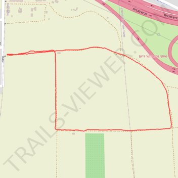
Name: מסלול לסיור עששיות בין שדות כפר מע"ש trail, distance, elevation, map, profile, GPS track

Start: Eilat, Gat Rimmon, Drom HaSharon Regional Council, Petah Tikva Subdistrict, Center District, 4974116, Israel (32.06569 34.89501)

End: Eilat, Gat Rimmon, Drom HaSharon Regional Council, Petah Tikva Subdistrict, Center District, 4974116, Israel (32.06571 34.89503)

Coordinates: 32.06317 34.89501 32.06595 34.90145

Gear up for your next adventure:

🧥Waterproof Jacket for Hiking - Breathable and rugged rain jacket for outdoor excursions
🧥Men's Rain Shells - Premium waterproof and breathable jackets for mountain weather
🛰️Satellite Messengers - Emergency SOS and two-way messaging for off-grid adventures
👖Convertible Hiking Pants - Versatile zip-off pants for changing altitudes and temperatures
🏫Relief Map Kits - Hands-on tools for teaching landforms and elevation

As an Amazon Associate, this site earns from qualifying purchases at no extra cost to you.