Make a donation
Gear up for your next adventure:
As an Amazon Associate, this site earns from qualifying purchases at no extra cost to you.
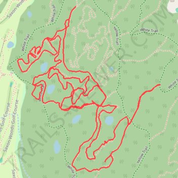
Saxon Woods Loop Hike
- Distance: 3.7 mi
- Elevation gain: 98 ft
- Maximum elevation: 210 ft
- Elevation loss: 98 ft
- Minimum elevation: 154 ft
- Moving time: 1 h 5 m
- Moving speed: 3.4 mph
- Maximum speed: 5.6 mph
- Total time: 1 h 7 m
- Global speed: 3.3 mph
Interactive trail map
Make a donation
Gear up for your next adventure:
As an Amazon Associate, this site earns from qualifying purchases at no extra cost to you.
Trail profile
- Distance: 3.7 mi
- Elevation gain: 98 ft
- Maximum elevation: 210 ft
- Elevation loss: 98 ft
- Minimum elevation: 154 ft
- Moving time: 1 h 5 m
- Moving speed: 3.4 mph
- Maximum speed: 5.6 mph
- Total time: 1 h 7 m
- Global speed: 3.3 mph
Make a donation
Gear up for your next adventure:
As an Amazon Associate, this site earns from qualifying purchases at no extra cost to you.
About this trail
Name: Saxon Woods Loop Hike trail, distance, elevation, map, profile, GPS track
Coordinates: 40.98235 -73.75768 40.98891 -73.75015
Topography: Westchester County topographic map, elevation, terrain
Make a donation
Gear up for your next adventure:
As an Amazon Associate, this site earns from qualifying purchases at no extra cost to you.
Other hiking, mountain biking, running and outdoor activity trails
Click on a trail to view its statistics, map and profile.
Saxon Woods Park - Yellow and White trails loop
United States > New York > Westchester County > Village of Scarsdale
Distance: 3.2 mi • Elevation gain: 308 ft • Maximum elevation: 210 ft
Saxon Woods Park
United States > New York > Westchester County > Village of Scarsdale
Distance: 3.0 mi • Elevation gain: 151 ft • Maximum elevation: 213 ft