Make a donation
Gear up for your next adventure:
As an Amazon Associate, this site earns from qualifying purchases at no extra cost to you.
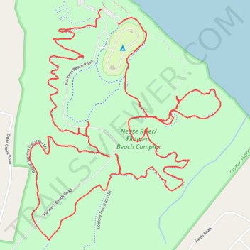
Flanners Beach and Croatan National Forest Loop
- Distance: 4.1 mi
- Elevation gain: 72 ft
- Maximum elevation: 52 ft
- Elevation loss: 72 ft
- Minimum elevation: 20 ft
- Moving time: 1 h 38 m
- Moving speed: 2.5 mph
- Maximum speed: 8.3 mph
- Total time: 1 h 45 m
- Global speed: 2.4 mph
Interactive trail map
Make a donation
Gear up for your next adventure:
As an Amazon Associate, this site earns from qualifying purchases at no extra cost to you.
Trail profile
- Distance: 4.1 mi
- Elevation gain: 72 ft
- Maximum elevation: 52 ft
- Elevation loss: 72 ft
- Minimum elevation: 20 ft
- Moving time: 1 h 38 m
- Moving speed: 2.5 mph
- Maximum speed: 8.3 mph
- Total time: 1 h 45 m
- Global speed: 2.4 mph
Make a donation
Gear up for your next adventure:
As an Amazon Associate, this site earns from qualifying purchases at no extra cost to you.
About this trail
Name: Flanners Beach and Croatan National Forest Loop trail, distance, elevation, map, profile, GPS track
Start: Flanners Beach Road, Craven County, North Carolina, United States (34.98342 -76.94927)
Coordinates: 34.97403 -76.95285 34.98342 -76.94340
Topography: Craven County topographic map, elevation, terrain
Make a donation
Gear up for your next adventure:
As an Amazon Associate, this site earns from qualifying purchases at no extra cost to you.
Other hiking, mountain biking, running and outdoor activity trails
Click on a trail to view its statistics, map and profile.
2026-06-26 12:39:01
United States > North Carolina > Craven County
Distance: 4.0 mi • Elevation gain: 89 ft • Maximum elevation: 49 ft
Neuse River Beach Swamp Trail and Flanners Beach Campground Loop in Croatan National Forest
United States > North Carolina > Craven County
Distance: 2.2 mi • Elevation gain: 69 ft • Maximum elevation: 46 ft
Morning hike at Flanners Beach and Croatan National Forest Loop
United States > North Carolina > Craven County
Distance: 1.9 mi • Elevation gain: 79 ft • Maximum elevation: 52 ft
Flanners Beach and Croatan National Forest Loop
United States > North Carolina > Craven County
Distance: 4.9 mi • Elevation gain: 75 ft • Maximum elevation: 49 ft
Make a donation
Gear up for your next adventure:
As an Amazon Associate, this site earns from qualifying purchases at no extra cost to you.
Flanners Beach / Neuse Campground Loop
United States > North Carolina > Craven County
Distance: 1.4 mi • Elevation gain: 36 ft • Maximum elevation: 49 ft