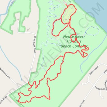
Flanners Beach and Croatan National Forest Loop
- Distance: 4.9 mi
- Elevation gain: 75 ft
- Maximum elevation: 49 ft
- Elevation loss: 75 ft
- Minimum elevation: 20 ft
- Moving time: 1 h 50 m
- Moving speed: 2.7 mph
- Maximum speed: 5.2 mph
- Total time: 2 h 7 m
- Global speed: 2.3 mph
Interactive trail map
Trail profile
- Distance: 4.9 mi
- Elevation gain: 75 ft
- Maximum elevation: 49 ft
- Elevation loss: 75 ft
- Minimum elevation: 20 ft
- Moving time: 1 h 50 m
- Moving speed: 2.7 mph
- Maximum speed: 5.2 mph
- Total time: 2 h 7 m
- Global speed: 2.3 mph
About this trail
Name: Flanners Beach and Croatan National Forest Loop trail, distance, elevation, map, profile, GPS track
Start: Flanners Beach Road, Craven County, North Carolina, United States (34.98313 -76.94877)
Coordinates: 34.96997 -76.95652 34.98313 -76.94504
Topography: Craven County topographic map, elevation, terrain
Other hiking, mountain biking, running and outdoor activity trails
Click on a trail to view its statistics, map and profile.
Neuse River/Flanners Beach Complex
United States > North Carolina > Craven County
Distance: 4.0 mi • Elevation gain: 46 ft • Maximum elevation: 49 ft
Neuse River/Flanners Beach Complex Loop
United States > North Carolina > Craven County
Distance: 4.0 mi • Elevation gain: 89 ft • Maximum elevation: 49 ft
Neuse River Beach Swamp Trail and Flanners Beach Campground Loop in Croatan National Forest
United States > North Carolina > Craven County
Distance: 2.2 mi • Elevation gain: 69 ft • Maximum elevation: 46 ft
Morning hike at Flanners Beach and Croatan National Forest Loop
United States > North Carolina > Craven County
Distance: 1.9 mi • Elevation gain: 79 ft • Maximum elevation: 52 ft
Flanners Beach and Croatan National Forest Loop
United States > North Carolina > Craven County
Distance: 4.1 mi • Elevation gain: 72 ft • Maximum elevation: 52 ft
Flanners Beach / Neuse Campground Loop
United States > North Carolina > Craven County
Distance: 1.4 mi • Elevation gain: 36 ft • Maximum elevation: 49 ft