Make a donation
Gear up for your next adventure:
As an Amazon Associate, this site earns from qualifying purchases at no extra cost to you.
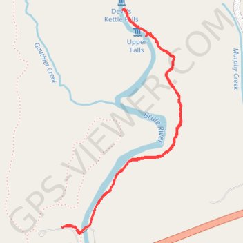
Devil's Kettle Falls via Superior Hiking Trail in Judge C. R. Magney State Park
The hike to Devil's Kettle Falls offers a blend of serene forest paths, river views, and the excitement of its famed geological mystery. The trail begins with a gentle incline through dense woodlands, punctuated by occasional river glimpses and resting spots, before reaching the steep staircase that leads to the falls. From the final overlook, visitors witness the Brule River’s split—one branch plunges into Devil’s Kettle, disappearing into a deep pothole, creating an experience both visually stunning and scientifically intriguing. #Hiking #Waterfall #River #Forest #Nature
- Distance: 2.0 mi
- Elevation gain: 413 ft
- Maximum elevation: 833 ft
- Elevation loss: 417 ft
- Minimum elevation: 623 ft
- Moving time: 45 m 19 s
- Moving speed: 2.6 mph
- Maximum speed: 5.6 mph
- Total time: 51 m 21 s
- Global speed: 2.3 mph
Interactive trail map
Make a donation
Gear up for your next adventure:
As an Amazon Associate, this site earns from qualifying purchases at no extra cost to you.
Trail profile
- Distance: 2.0 mi
- Elevation gain: 413 ft
- Maximum elevation: 833 ft
- Elevation loss: 417 ft
- Minimum elevation: 623 ft
- Moving time: 45 m 19 s
- Moving speed: 2.6 mph
- Maximum speed: 5.6 mph
- Total time: 51 m 21 s
- Global speed: 2.3 mph
Make a donation
Gear up for your next adventure:
As an Amazon Associate, this site earns from qualifying purchases at no extra cost to you.
About this trail
Name: Devil's Kettle Falls via Superior Hiking Trail in Judge C. R. Magney State Park trail, distance, elevation, map, profile, GPS track
Start: Superior Hiking Trail, East Cook, Cook County, Minnesota, United States (47.81989 -90.05293)
End: Superior Hiking Trail, East Cook, Cook County, Minnesota, United States (47.81979 -90.05321)
Coordinates: 47.81952 -90.05321 47.82903 -90.04567
Topography: Cook County topographic map, elevation, terrain
Make a donation
Gear up for your next adventure:
As an Amazon Associate, this site earns from qualifying purchases at no extra cost to you.