Make a donation
Gear up for your next adventure:
As an Amazon Associate, this site earns from qualifying purchases at no extra cost to you.
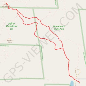
Mount Monadnock Loop via White Dot Trail and White Cross Trail in Monadnock State Park
The Mount Monadnock Loop offers a diverse hiking experience with a combination of challenging rock scrambles and scenic views. The ascent via the White Dot Trail is steep and demanding, with plenty of rocky terrain, while the White Cross Trail provides a somewhat gentler but still rugged descent, featuring striking forested areas and open ledges. Hikers are rewarded with panoramic vistas at the summit, extending as far as Boston on clear days, making this hike a satisfying and memorable challenge for those prepared for the rocky sections. #Hiking #Loop #Mountain #Rock #Forest #Nature
- Distance: 4.0 mi
- Elevation gain: 1,736 ft
- Maximum elevation: 3,110 ft
- Elevation loss: 1,732 ft
- Minimum elevation: 1,375 ft
- Moving time: 2 h 36 m
- Moving speed: 1.5 mph
- Maximum speed: 5.3 mph
- Total time: 3 h 24 m
- Global speed: 1.2 mph
Interactive trail map
Make a donation
Gear up for your next adventure:
As an Amazon Associate, this site earns from qualifying purchases at no extra cost to you.
Trail profile
- Distance: 4.0 mi
- Elevation gain: 1,736 ft
- Maximum elevation: 3,110 ft
- Elevation loss: 1,732 ft
- Minimum elevation: 1,375 ft
- Moving time: 2 h 36 m
- Moving speed: 1.5 mph
- Maximum speed: 5.3 mph
- Total time: 3 h 24 m
- Global speed: 1.2 mph
Make a donation
Gear up for your next adventure:
As an Amazon Associate, this site earns from qualifying purchases at no extra cost to you.
About this trail
Name: Mount Monadnock Loop via White Dot Trail and White Cross Trail in Monadnock State Park trail, distance, elevation, map, profile, GPS track
Coordinates: 42.84462 -72.10803 42.86137 -72.08686
Topography: Cheshire County topographic map, elevation, terrain
Make a donation
Gear up for your next adventure:
As an Amazon Associate, this site earns from qualifying purchases at no extra cost to you.
Other hiking, mountain biking, running and outdoor activity trails
Click on a trail to view its statistics, map and profile.
Bald Rock, Paradise Valley trail and others in the Monadnock State Park
United States > New Hampshire > Cheshire County > Jaffrey
Distance: 4.7 mi • Elevation gain: 1,804 ft • Maximum elevation: 2,920 ft
Lost Paradise Valley Loop Trail
United States > New Hampshire > Cheshire County > Jaffrey
Distance: 4.8 mi • Elevation gain: 1,804 ft • Maximum elevation: 2,920 ft
Lost Smith Trail
United States > New Hampshire > Cheshire County > Jaffrey
Distance: 5.3 mi • Elevation gain: 1,660 ft • Maximum elevation: 3,117 ft
Make a donation
Gear up for your next adventure:
As an Amazon Associate, this site earns from qualifying purchases at no extra cost to you.