Make a donation
Gear up for your next adventure:
As an Amazon Associate, this site earns from qualifying purchases at no extra cost to you.
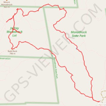
Bald Rock, Paradise Valley trail and others in the Monadnock State Park
- Distance: 4.7 mi
- Elevation gain: 1,804 ft
- Maximum elevation: 2,920 ft
- Elevation loss: 1,801 ft
- Minimum elevation: 1,391 ft
- Moving time: 3 h 24 m
- Moving speed: 1.4 mph
- Maximum speed: 4.8 mph
- Total time: 4 h 17 m
- Global speed: 1.1 mph
Interactive trail map
Make a donation
Gear up for your next adventure:
As an Amazon Associate, this site earns from qualifying purchases at no extra cost to you.
Trail profile
- Distance: 4.7 mi
- Elevation gain: 1,804 ft
- Maximum elevation: 2,920 ft
- Elevation loss: 1,801 ft
- Minimum elevation: 1,391 ft
- Moving time: 3 h 24 m
- Moving speed: 1.4 mph
- Maximum speed: 4.8 mph
- Total time: 4 h 17 m
- Global speed: 1.1 mph
Make a donation
Gear up for your next adventure:
As an Amazon Associate, this site earns from qualifying purchases at no extra cost to you.
About this trail
Name: Bald Rock, Paradise Valley trail and others in the Monadnock State Park trail, distance, elevation, map, profile, GPS track
Start: White Dot Trail, Jaffrey, Cheshire County, New Hampshire, United States (42.84568 -72.08867)
End: Poole Road, Jaffrey, Cheshire County, New Hampshire, 03452, United States (42.84580 -72.08845)
Coordinates: 42.84568 -72.10822 42.86087 -72.08845
Topography: Cheshire County topographic map, elevation, terrain
Make a donation
Gear up for your next adventure:
As an Amazon Associate, this site earns from qualifying purchases at no extra cost to you.
Other hiking, mountain biking, running and outdoor activity trails
Click on a trail to view its statistics, map and profile.
Mount Monadnock Loop via White Dot Trail and White Cross Trail in Monadnock State Park
United States > New Hampshire > Cheshire County > Jaffrey
The Mount Monadnock Loop offers a diverse hiking experience with a combination of challenging rock scrambles and scenic views. The ascent via the White Dot Trail is steep and demanding, with plenty of rocky terrain, while the White Cross Trail provides a somewhat gentler but still rugged descent, featuring…
Distance: 4.0 mi • Elevation gain: 1,736 ft • Maximum elevation: 3,110 ft
Mount Monadnock and Monte Rosa loop via Smith Trail
United States > New Hampshire > Cheshire County > Jaffrey
Distance: 5.2 mi • Elevation gain: 1,696 ft • Maximum elevation: 3,117 ft
Lost Paradise Valley Loop Trail
United States > New Hampshire > Cheshire County > Jaffrey
Distance: 4.8 mi • Elevation gain: 1,804 ft • Maximum elevation: 2,920 ft
Make a donation
Gear up for your next adventure:
As an Amazon Associate, this site earns from qualifying purchases at no extra cost to you.
Lost Smith Trail
United States > New Hampshire > Cheshire County > Jaffrey
Distance: 5.3 mi • Elevation gain: 1,660 ft • Maximum elevation: 3,117 ft