Shorthills trails perimeter watch trace
Thorold Running
- Distance: 10.7 mi
- Elevation gain: 935 ft
- Maximum elevation: 554 ft
- Elevation loss: 935 ft
- Minimum elevation: 318 ft
- Moving time: 1 h 48 m
- Moving speed: 5.9 mph
- Maximum speed: 15.4 mph
- Total time: 1 h 49 m
- Global speed: 5.9 mph
Interactive trail map
Trail profile
- Distance: 10.7 mi
- Elevation gain: 935 ft
- Maximum elevation: 554 ft
- Elevation loss: 935 ft
- Minimum elevation: 318 ft
- Moving time: 1 h 48 m
- Moving speed: 5.9 mph
- Maximum speed: 15.4 mph
- Total time: 1 h 49 m
- Global speed: 5.9 mph
About this trail
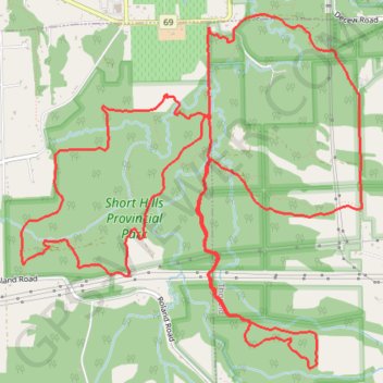
Name: Shorthills trails perimeter watch trace trail, distance, elevation, map, profile, GPS track
Coordinates: 43.08348 -79.30572 43.10912 -79.27191
Other hiking, mountain biking, running and outdoor activity trails
Click on a trail to view its statistics, map and profile.
Niagara Falls - Hamilton
Canada > Ontario > Niagara Region > Niagara Falls
#Bike
Distance: 52.3 mi • Elevation gain: 1,762 ft • Maximum elevation: 686 ft