Make a donation
Gear up for your next adventure:
As an Amazon Associate, this site earns from qualifying purchases at no extra cost to you.
Virginia Falls and Saint Mary Falls from Saint Mary Lake in Glacier National Park
The hike to Virginia and Saint Mary Falls is a delightful adventure for nature lovers! As you meander along the trail, you'll be treated to stunning views of rugged mountains like Little Chief and Dusty Star, while the lush greenery envelops you in a serene atmosphere. The highlight, of course, is witnessing the breathtaking waterfalls; Saint Mary Falls cascades in a magnificent three-tier display, and Virginia Falls enchants with its majestic drop, all while the cool mist refreshes you on a warm day. #Hiking #Mountain #River #Waterfall #Forest #Nature #Lake
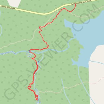
- Distance: 3.8 mi
- Elevation gain: 751 ft
- Maximum elevation: 4,908 ft
- Elevation loss: 755 ft
- Minimum elevation: 4,521 ft
- Moving time: 1 h 28 m
- Moving speed: 2.6 mph
- Maximum speed: 4.7 mph
- Total time: 1 h 53 m
- Global speed: 2.0 mph
Interactive trail map
Make a donation
Gear up for your next adventure:
As an Amazon Associate, this site earns from qualifying purchases at no extra cost to you.
Trail profile
- Distance: 3.8 mi
- Elevation gain: 751 ft
- Maximum elevation: 4,908 ft
- Elevation loss: 755 ft
- Minimum elevation: 4,521 ft
- Moving time: 1 h 28 m
- Moving speed: 2.6 mph
- Maximum speed: 4.7 mph
- Total time: 1 h 53 m
- Global speed: 2.0 mph
Make a donation
Gear up for your next adventure:
As an Amazon Associate, this site earns from qualifying purchases at no extra cost to you.
About this trail
Name: Virginia Falls and Saint Mary Falls from Saint Mary Lake in Glacier National Park trail, distance, elevation, map, profile, GPS track
Start: Gunsight Horse Trail Cutoff, Glacier County, Montana, United States (48.67520 -113.60456)
End: Gunsight Horse Trail Cutoff, Glacier County, Montana, United States (48.67513 -113.60452)
Coordinates: 48.66051 -113.61550 48.67520 -113.60434
Topography: Glacier County topographic map, elevation, terrain
Make a donation
Gear up for your next adventure:
As an Amazon Associate, this site earns from qualifying purchases at no extra cost to you.
Other hiking, mountain biking, running and outdoor activity trails
Click on a trail to view its statistics, map and profile.
Virginia Falls and St. Mary Falls in Glacier National Park
United States > Montana > Glacier County
The St. Mary and Virginia Falls Trail in Glacier National Park offers a captivating journey through diverse landscapes. Starting near St. Mary Lake, hikers traverse areas affected by past wildfires, providing a unique contrast between new growth and charred remnants. Along the path, the trail meanders…
Distance: 3.8 mi • Elevation gain: 758 ft • Maximum elevation: 4,911 ft