Thank you for supporting this site ❤️
Make a donation
Make a donation
Gear up for your next adventure:
As an Amazon Associate, this site earns from qualifying purchases at no extra cost to you.
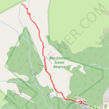
Ben Lomond Track to Saddle in Ben Lomond Scenic Reserve
- Distance: 4.7 mi
- Elevation gain: 1,831 ft
- Maximum elevation: 4,288 ft
- Elevation loss: 2,372 ft
- Minimum elevation: 2,205 ft
- Moving time: 2 h 30 m
- Moving speed: 1.9 mph
- Maximum speed: 7.3 mph
- Total time: 3 h 10 m
- Global speed: 1.5 mph
Interactive trail map
Thank you for supporting this site ❤️
Make a donation
Make a donation
Gear up for your next adventure:
As an Amazon Associate, this site earns from qualifying purchases at no extra cost to you.
Trail profile
- Distance: 4.7 mi
- Elevation gain: 1,831 ft
- Maximum elevation: 4,288 ft
- Elevation loss: 2,372 ft
- Minimum elevation: 2,205 ft
- Moving time: 2 h 30 m
- Moving speed: 1.9 mph
- Maximum speed: 7.3 mph
- Total time: 3 h 10 m
- Global speed: 1.5 mph
Thank you for supporting this site ❤️
Make a donation
Make a donation
Gear up for your next adventure:
As an Amazon Associate, this site earns from qualifying purchases at no extra cost to you.
About this trail
Name: Ben Lomond Track to Saddle in Ben Lomond Scenic Reserve trail, distance, elevation, map, profile, GPS track
Coordinates: -45.02709 168.62798 -45.00214 168.65091
Thank you for supporting this site ❤️
Make a donation
Make a donation
Gear up for your next adventure:
As an Amazon Associate, this site earns from qualifying purchases at no extra cost to you.