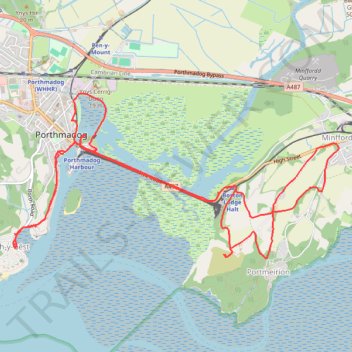
Porthmadog loop
- Distance: 8.4 mi
- Elevation gain: 696 ft
- Maximum elevation: 259 ft
- Elevation loss: 696 ft
- Minimum elevation: -7 ft
- Moving time: 3 h 52 m
- Moving speed: 2.2 mph
- Maximum speed: 3.5 mph
- Total time: 5 h 35 m
- Global speed: 1.5 mph
Interactive trail map
Trail profile
- Distance: 8.4 mi
- Elevation gain: 696 ft
- Maximum elevation: 259 ft
- Elevation loss: 696 ft
- Minimum elevation: -7 ft
- Moving time: 3 h 52 m
- Moving speed: 2.2 mph
- Maximum speed: 3.5 mph
- Total time: 5 h 35 m
- Global speed: 1.5 mph
About this trail
Name: Porthmadog loop trail, distance, elevation, map, profile, GPS track
Start: Garden Place, Porthmadog, Gwynedd, Wales, LL49 9DD, United Kingdom (52.92677 -4.12816)
End: Garden Place, Porthmadog, Gwynedd, Wales, LL49 9DD, United Kingdom (52.92678 -4.12808)
Coordinates: 52.91457 -4.13671 52.92919 -4.08895
Other hiking, mountain biking, running and outdoor activity trails
Click on a trail to view its statistics, map and profile.
Walk along the coast and beach between Borth-y-Gêst and Morfa Bychan
United Kingdom > Wales > Gwynedd > Borth-y-Gêst
Distance: 2.6 mi • Elevation gain: 223 ft • Maximum elevation: 105 ft
Moel-Y-Gest Loop Trail
United Kingdom > Wales > Gwynedd > Porthmadog
Distance: 4.1 mi • Elevation gain: 965 ft • Maximum elevation: 814 ft
Borth-y-Gest Loop Walk
United Kingdom > Wales > Gwynedd > Porthmadog
Distance: 3.9 mi • Elevation gain: 417 ft • Maximum elevation: 112 ft