Make a donation
Gear up for your next adventure:
As an Amazon Associate, this site earns from qualifying purchases at no extra cost to you.
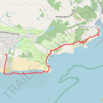
Walk along the coast and beach between Borth-y-Gêst and Morfa Bychan
- Distance: 2.6 mi
- Elevation gain: 223 ft
- Maximum elevation: 105 ft
- Elevation loss: 217 ft
- Minimum elevation: -7 ft
- Moving time: 1 h 7 m
- Moving speed: 2.3 mph
- Maximum speed: 7.0 mph
- Total time: 2 h 17 m
- Global speed: 1.1 mph
Interactive trail map
Make a donation
Gear up for your next adventure:
As an Amazon Associate, this site earns from qualifying purchases at no extra cost to you.
Trail profile
- Distance: 2.6 mi
- Elevation gain: 223 ft
- Maximum elevation: 105 ft
- Elevation loss: 217 ft
- Minimum elevation: -7 ft
- Moving time: 1 h 7 m
- Moving speed: 2.3 mph
- Maximum speed: 7.0 mph
- Total time: 2 h 17 m
- Global speed: 1.1 mph
Make a donation
Gear up for your next adventure:
As an Amazon Associate, this site earns from qualifying purchases at no extra cost to you.
About this trail
Name: Walk along the coast and beach between Borth-y-Gêst and Morfa Bychan trail, distance, elevation, map, profile, GPS track
Coordinates: 52.90607 -4.16675 52.91528 -4.13482
Make a donation
Gear up for your next adventure:
As an Amazon Associate, this site earns from qualifying purchases at no extra cost to you.
Other hiking, mountain biking, running and outdoor activity trails
Click on a trail to view its statistics, map and profile.
Moel-Y-Gest Loop Trail
United Kingdom > Wales > Gwynedd > Porthmadog
Distance: 4.1 mi • Elevation gain: 965 ft • Maximum elevation: 814 ft
Borth-y-Gest Loop Walk
United Kingdom > Wales > Gwynedd > Porthmadog
Distance: 3.9 mi • Elevation gain: 417 ft • Maximum elevation: 112 ft
Porthmadog loop
United Kingdom > Wales > Gwynedd > Porthmadog
Distance: 8.4 mi • Elevation gain: 696 ft • Maximum elevation: 259 ft