Thank you for supporting this site ❤️
Make a donation
Make a donation
Gear up for your next adventure:
As an Amazon Associate, this site earns from qualifying purchases at no extra cost to you.
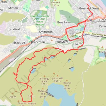
Dunrod Hill and Hillside Hill loop from Greenock West - Clyde Muirshiel Regional Park
- Distance: 11.8 mi
- Elevation gain: 1,345 ft
- Maximum elevation: 955 ft
- Elevation loss: 1,342 ft
- Minimum elevation: 52 ft
- Moving time: 1 h 41 m
- Moving speed: 7.0 mph
- Maximum speed: 13.6 mph
- Total time: 1 h 43 m
- Global speed: 6.8 mph
Interactive trail map
Thank you for supporting this site ❤️
Make a donation
Make a donation
Gear up for your next adventure:
As an Amazon Associate, this site earns from qualifying purchases at no extra cost to you.
Trail profile
- Distance: 11.8 mi
- Elevation gain: 1,345 ft
- Maximum elevation: 955 ft
- Elevation loss: 1,342 ft
- Minimum elevation: 52 ft
- Moving time: 1 h 41 m
- Moving speed: 7.0 mph
- Maximum speed: 13.6 mph
- Total time: 1 h 43 m
- Global speed: 6.8 mph
Thank you for supporting this site ❤️
Make a donation
Make a donation
Gear up for your next adventure:
As an Amazon Associate, this site earns from qualifying purchases at no extra cost to you.
About this trail
Name: Dunrod Hill and Hillside Hill loop from Greenock West - Clyde Muirshiel Regional Park trail, distance, elevation, map, profile, GPS track
Coordinates: 55.91375 -4.82402 55.95379 -4.76618
Thank you for supporting this site ❤️
Make a donation
Make a donation
Gear up for your next adventure:
As an Amazon Associate, this site earns from qualifying purchases at no extra cost to you.
Other hiking, mountain biking, running and outdoor activity trails
Click on a trail to view its statistics, map and profile.