Thank you for supporting this site ❤️
Make a donation
Make a donation
Gear up for your next adventure:
As an Amazon Associate, this site earns from qualifying purchases at no extra cost to you.
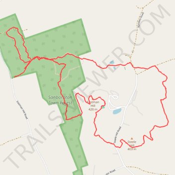
Sanbornton Town Forest, Eastman Hill and Steele Hill Loop
- Distance: 5.0 mi
- Elevation gain: 863 ft
- Maximum elevation: 1,378 ft
- Elevation loss: 876 ft
- Minimum elevation: 866 ft
- Moving time: 2 h 12 m
- Moving speed: 2.3 mph
- Maximum speed: 3.9 mph
- Total time: 2 h 20 m
- Global speed: 2.2 mph
Interactive trail map
Thank you for supporting this site ❤️
Make a donation
Make a donation
Gear up for your next adventure:
As an Amazon Associate, this site earns from qualifying purchases at no extra cost to you.
Trail profile
- Distance: 5.0 mi
- Elevation gain: 863 ft
- Maximum elevation: 1,378 ft
- Elevation loss: 876 ft
- Minimum elevation: 866 ft
- Moving time: 2 h 12 m
- Moving speed: 2.3 mph
- Maximum speed: 3.9 mph
- Total time: 2 h 20 m
- Global speed: 2.2 mph
Thank you for supporting this site ❤️
Make a donation
Make a donation
Gear up for your next adventure:
As an Amazon Associate, this site earns from qualifying purchases at no extra cost to you.
About this trail
Name: Sanbornton Town Forest, Eastman Hill and Steele Hill Loop trail, distance, elevation, map, profile, GPS track
Coordinates: 43.54688 -71.59005 43.55916 -71.56724
Topography: Belknap County topographic map, elevation, terrain
Thank you for supporting this site ❤️
Make a donation
Make a donation
Gear up for your next adventure:
As an Amazon Associate, this site earns from qualifying purchases at no extra cost to you.
Other hiking, mountain biking, running and outdoor activity trails
Click on a trail to view its statistics, map and profile.