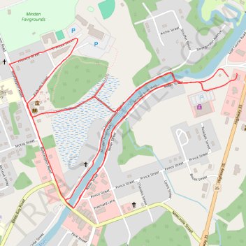
Minden Trails
- Distance: 3.4 mi
- Elevation gain: 89 ft
- Maximum elevation: 932 ft
- Elevation loss: 89 ft
- Minimum elevation: 886 ft
- Moving time: 30 m 52 s
- Moving speed: 6.7 mph
- Maximum speed: 8.7 mph
- Total time: 30 m 52 s
- Global speed: 6.7 mph
Interactive trail map
Trail profile
- Distance: 3.4 mi
- Elevation gain: 89 ft
- Maximum elevation: 932 ft
- Elevation loss: 89 ft
- Minimum elevation: 886 ft
- Moving time: 30 m 52 s
- Moving speed: 6.7 mph
- Maximum speed: 8.7 mph
- Total time: 30 m 52 s
- Global speed: 6.7 mph
About this trail
Name: Minden Trails trail, distance, elevation, map, profile, GPS track
Coordinates: 44.92552 -78.72880 44.93255 -78.71551
Other hiking, mountain biking, running and outdoor activity trails
Click on a trail to view its statistics, map and profile.