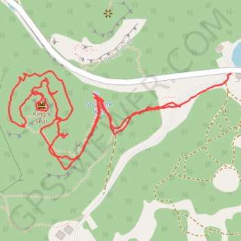
Walk around King's Seat. Tracing lines of defence and paths
- Distance: 1.4 mi
- Elevation gain: 243 ft
- Maximum elevation: 499 ft
- Elevation loss: 230 ft
- Minimum elevation: 341 ft
- Moving time: 49 m 40 s
- Moving speed: 1.6 mph
- Maximum speed: 4.8 mph
- Total time: 1 h 3 m
- Global speed: 1.3 mph
Interactive trail map
Trail profile
- Distance: 1.4 mi
- Elevation gain: 243 ft
- Maximum elevation: 499 ft
- Elevation loss: 230 ft
- Minimum elevation: 341 ft
- Moving time: 49 m 40 s
- Moving speed: 1.6 mph
- Maximum speed: 4.8 mph
- Total time: 1 h 3 m
- Global speed: 1.3 mph
About this trail
Name: Walk around King's Seat. Tracing lines of defence and paths trail, distance, elevation, map, profile, GPS track
Start: A9, Inver, Perth and Kinross, Scotland, PH8 0HX, United Kingdom (56.56840 -3.60886)
End: Polney Lodge, A9, Inver, Perth and Kinross, Scotland, PH8 0HX, United Kingdom (56.56903 -3.60710)
Coordinates: 56.56721 -3.61479 56.56907 -3.60710
Other hiking, mountain biking, running and outdoor activity trails
Click on a trail to view its statistics, map and profile.
Loop from The Hermitage to Craigvinean Forest Ruins
United Kingdom > Scotland > Perth and Kinross > Inver
Distance: 12.5 mi • Elevation gain: 1,926 ft • Maximum elevation: 1,526 ft
EMTB Gravel: Murthly - Birnam - Loop
United Kingdom > Scotland > Perth and Kinross > Newlands
Around Dunkeld, Perthshire Scotland
Distance: 28.8 mi • Elevation gain: 2,851 ft • Maximum elevation: 1,001 ft
Falls of the Braan and River Tay loop trail
United Kingdom > Scotland > Perth and Kinross > Dunkeld > Inchmagrannachan
Distance: 6.8 mi • Elevation gain: 768 ft • Maximum elevation: 610 ft
Walk over A9 bridge over River Braan by pedestrian pavement (sidewalk) and small diversion for SGN gas pipeline route then Fiddlers path
United Kingdom > Scotland > Perth and Kinross > Dunkeld
Distance: 3.7 mi • Elevation gain: 259 ft • Maximum elevation: 249 ft
Craigvinean Forest Loop MTB, Dunkeld, Perthshire
United Kingdom > Scotland > Perth and Kinross > Inver
Mountain Bike Ride, UK, Perthshire, Dunkeld
Distance: 13.3 mi • Elevation gain: 1,844 ft • Maximum elevation: 1,188 ft