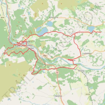
EMTB Gravel: Murthly - Birnam - Loop
Around Dunkeld, Perthshire Scotland
- Distance: 28.8 mi
- Elevation gain: 2,851 ft
- Maximum elevation: 1,001 ft
- Elevation loss: 2,854 ft
- Minimum elevation: 131 ft
- Moving time: 3 h 59 m
- Moving speed: 7.2 mph
- Maximum speed: 26.0 mph
- Total time: 6 h 3 m
- Global speed: 4.8 mph
Interactive trail map
Trail profile
- Distance: 28.8 mi
- Elevation gain: 2,851 ft
- Maximum elevation: 1,001 ft
- Elevation loss: 2,854 ft
- Minimum elevation: 131 ft
- Moving time: 3 h 59 m
- Moving speed: 7.2 mph
- Maximum speed: 26.0 mph
- Total time: 6 h 3 m
- Global speed: 4.8 mph
About this trail
Name: EMTB Gravel: Murthly - Birnam - Loop trail, distance, elevation, map, profile, GPS track
Coordinates: 56.52633 -3.63413 56.57853 -3.42217
Other hiking, mountain biking, running and outdoor activity trails
Click on a trail to view its statistics, map and profile.
The Knockie, Marlee Loch and Loch of Clunie Loop
United Kingdom > Scotland > Perth and Kinross > Craigie
Loop MTB / run / hike around Blairgowrie via The Knockie, Marlee Loch and Loch of Clunie. #Hiking #Loop #Nature #Countryside #Lake
Distance: 10.7 mi • Elevation gain: 889 ft • Maximum elevation: 666 ft
Loop Gravel Ride around Blairgowrie and Rattray between Loch of Clunie and Alyth
United Kingdom > Scotland > Perth and Kinross > Newlands
Distance: 24.7 mi • Elevation gain: 1,736 ft • Maximum elevation: 922 ft
Cally Loch Mountain Bike Ride, Dunkeld
United Kingdom > Scotland > Perth and Kinross
Distance: 24.1 mi • Elevation gain: 1,985 ft • Maximum elevation: 620 ft
Inchtuthil Roman Legionary Fortress
United Kingdom > Scotland > Perth and Kinross > Newlands
Inchtuthil Redoubt
Distance: 8.7 mi • Elevation gain: 427 ft • Maximum elevation: 318 ft
Falls of the Braan and River Tay loop trail
United Kingdom > Scotland > Perth and Kinross > Dunkeld > Inchmagrannachan
Distance: 6.8 mi • Elevation gain: 768 ft • Maximum elevation: 610 ft
Tracks, MTB and off track sections to visit the Rocking Stone and Polney Crag
United Kingdom > Scotland > Perth and Kinross > Dunkeld > Inchmagrannachan
Distance: 2.3 mi • Elevation gain: 564 ft • Maximum elevation: 1,053 ft
Walk over A9 bridge over River Braan by pedestrian pavement (sidewalk) and small diversion for SGN gas pipeline route then Fiddlers path
United Kingdom > Scotland > Perth and Kinross > Dunkeld
Distance: 3.7 mi • Elevation gain: 259 ft • Maximum elevation: 249 ft
Mountain Bike loop ride around Murthly, Perthshire Scotland
United Kingdom > Scotland > Perth and Kinross > Murthly > Gellyburn
UK, Perthshire, Dunkeld, Murthly
Distance: 11.2 mi • Elevation gain: 978 ft • Maximum elevation: 584 ft
Black Hill Roman Watch Tower - Around Meikleour, Perthshire
United Kingdom > Scotland > Perth and Kinross > Newlands
Distance: 12.1 mi • Elevation gain: 807 ft • Maximum elevation: 453 ft
Craigvinean Forest Loop MTB, Dunkeld, Perthshire
United Kingdom > Scotland > Perth and Kinross > Inver
Mountain Bike Ride, UK, Perthshire, Dunkeld
Distance: 13.3 mi • Elevation gain: 1,844 ft • Maximum elevation: 1,188 ft
Ninewells Kerb Cairn
United Kingdom > Scotland > Perth and Kinross
Distance: 7.2 mi • Elevation gain: 545 ft • Maximum elevation: 469 ft
Mountain Bike Ride Around Clunie, Perthshire
United Kingdom > Scotland > Perth and Kinross
UK, Perthshire, Clunie
Distance: 10.4 mi • Elevation gain: 1,027 ft • Maximum elevation: 689 ft
Mountain Bike Ride around Craigvinean Forest
United Kingdom > Scotland > Perth and Kinross > Inver
UK, Perthshire, Dunkeld
Distance: 4.8 mi • Elevation gain: 1,076 ft • Maximum elevation: 1,096 ft
Ninewells Kerb Cairn & Easter Cult Stones
United Kingdom > Scotland > Perth and Kinross
Around Clunie, Perthshire
Distance: 9.6 mi • Elevation gain: 922 ft • Maximum elevation: 673 ft
Discovering Newtyle Hill tracks by bicycle
United Kingdom > Scotland > Perth and Kinross > Dunkeld
Distance: 6.4 mi • Elevation gain: 1,083 ft • Maximum elevation: 922 ft
Walk around King's Seat. Tracing lines of defence and paths
United Kingdom > Scotland > Perth and Kinross > Inver
Distance: 1.4 mi • Elevation gain: 243 ft • Maximum elevation: 499 ft
Around Newtyle Hill, Dunkeld, Perthshire
United Kingdom > Scotland > Perth and Kinross
Distance: 17.5 mi • Elevation gain: 1,965 ft • Maximum elevation: 912 ft
Kinclaven Wood - Stanley - Bankfoot Loop
United Kingdom > Scotland > Perth and Kinross > Newlands
Distance: 26.7 mi • Elevation gain: 1,795 ft • Maximum elevation: 449 ft
Mountain Bike Ride Above Clunie
United Kingdom > Scotland > Perth and Kinross > Craigie
#UK #Perthshire #Clunie
Distance: 5.8 mi • Elevation gain: 620 ft • Maximum elevation: 620 ft
Gravel ride around Murthly Castle
United Kingdom > Scotland > Perth and Kinross > Murthly > Gellyburn
Distance: 6.2 mi • Elevation gain: 417 ft • Maximum elevation: 404 ft
Around Blairgowrie, Scotland
United Kingdom > Scotland > Perth and Kinross > Craigie
UK, Perthshire, Blairgowrie
Distance: 12.2 mi • Elevation gain: 571 ft • Maximum elevation: 266 ft
Around Clunie, Perthshire
United Kingdom > Scotland > Perth and Kinross
Afternoon Workout. UK, Perthshire, Blairgowrie
Distance: 10.2 mi • Elevation gain: 1,014 ft • Maximum elevation: 614 ft
Around Newtyle Hill near Dunkeld
United Kingdom > Scotland > Perth and Kinross > Clunie
Distance: 15.2 mi • Elevation gain: 1,949 ft • Maximum elevation: 912 ft
Around Clunie, Perthshire
United Kingdom > Scotland > Perth and Kinross > Clunie
UK, Perthshire, Blairgowrie
Distance: 4.6 mi • Elevation gain: 499 ft • Maximum elevation: 617 ft
Mountain Bike Ride Above Clunie
United Kingdom > Scotland > Perth and Kinross
Distance: 9.4 mi • Elevation gain: 912 ft • Maximum elevation: 673 ft
Around Spittalfield, Scotland
United Kingdom > Scotland > Perth and Kinross
Distance: 11.9 mi • Elevation gain: 912 ft • Maximum elevation: 449 ft
North of Loch of Clunie
United Kingdom > Scotland > Perth and Kinross > Clunie
UK, Perthshire, Clunie
Distance: 7.6 mi • Elevation gain: 853 ft • Maximum elevation: 620 ft
Around Loch Ordie
United Kingdom > Scotland > Perth and Kinross
Mountain Bike Ride, UK, Perthshire, Dunkeld
Distance: 22.3 mi • Elevation gain: 1,900 ft • Maximum elevation: 984 ft
King's Myre Loop
United Kingdom > Scotland > Perth and Kinross > Newlands
Distance: 24.7 mi • Elevation gain: 1,198 ft • Maximum elevation: 348 ft
Inver Wood Roads
United Kingdom > Scotland > Perth and Kinross > Inver
Finding the route of the old roads
Distance: 1.0 mi • Elevation gain: 112 ft • Maximum elevation: 272 ft
Track of the split tracks 😅
United Kingdom > Scotland > Perth and Kinross > Inver
Distance: 0.7 mi • Elevation gain: 56 ft • Maximum elevation: 223 ft