Thank you for supporting this site ❤️
Make a donation
Make a donation
Gear up for your next adventure:
As an Amazon Associate, this site earns from qualifying purchases at no extra cost to you.
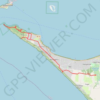
Point Nepean National Park
- Distance: 39.5 mi
- Elevation gain: 2,195 ft
- Maximum elevation: 138 ft
- Elevation loss: 2,185 ft
- Minimum elevation: 0 ft
- Moving time: 3 h 25 m
- Moving speed: 11.5 mph
- Maximum speed: 49.7 mph
- Total time: 4 h 38 m
- Global speed: 8.5 mph
Interactive trail map
Thank you for supporting this site ❤️
Make a donation
Make a donation
Gear up for your next adventure:
As an Amazon Associate, this site earns from qualifying purchases at no extra cost to you.
Trail profile
- Distance: 39.5 mi
- Elevation gain: 2,195 ft
- Maximum elevation: 138 ft
- Elevation loss: 2,185 ft
- Minimum elevation: 0 ft
- Moving time: 3 h 25 m
- Moving speed: 11.5 mph
- Maximum speed: 49.7 mph
- Total time: 4 h 38 m
- Global speed: 8.5 mph
Thank you for supporting this site ❤️
Make a donation
Make a donation
Gear up for your next adventure:
As an Amazon Associate, this site earns from qualifying purchases at no extra cost to you.
About this trail
Name: Point Nepean National Park trail, distance, elevation, map, profile, GPS track
Coordinates: -38.39930 144.65208 -38.30306 144.87306
Thank you for supporting this site ❤️
Make a donation
Make a donation
Gear up for your next adventure:
As an Amazon Associate, this site earns from qualifying purchases at no extra cost to you.
Other hiking, mountain biking, running and outdoor activity trails
Click on a trail to view its statistics, map and profile.
Walk in Rye via Orr Point
Australia > Victoria > Melbourne
Distance: 3.7 mi • Elevation gain: 463 ft • Maximum elevation: 112 ft