Thank you for supporting this site ❤️
Make a donation
Make a donation
Gear up for your next adventure:
As an Amazon Associate, this site earns from qualifying purchases at no extra cost to you.
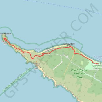
Coles Track - Cheviot Hill - Fort Nepean
Interactive trail map
Thank you for supporting this site ❤️
Make a donation
Make a donation
Gear up for your next adventure:
As an Amazon Associate, this site earns from qualifying purchases at no extra cost to you.
Trail profile
- Distance: 3.2 mi
- Elevation gain: 295 ft
- Maximum elevation: 135 ft
- Elevation loss: 305 ft
- Minimum elevation: 7 ft
- Moving time: 1 h 8 m
- Moving speed: 2.8 mph
- Maximum speed: 8.9 mph
- Total time: 1 h 23 m
- Global speed: 2.3 mph
Thank you for supporting this site ❤️
Make a donation
Make a donation
Gear up for your next adventure:
As an Amazon Associate, this site earns from qualifying purchases at no extra cost to you.
About this trail
Name: Coles Track - Cheviot Hill - Fort Nepean trail, distance, elevation, map, profile, GPS track
Coordinates: -38.31210 144.65215 -38.30321 144.69377
Thank you for supporting this site ❤️
Make a donation
Make a donation
Gear up for your next adventure:
As an Amazon Associate, this site earns from qualifying purchases at no extra cost to you.
Other hiking, mountain biking, running and outdoor activity trails
Click on a trail to view its statistics, map and profile.