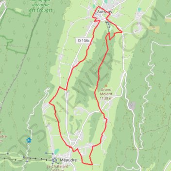
B12 A la découverte des deux villages, départ Autr
- Distance: 10.1 mi
- Elevation gain: 1,129 ft
- Maximum elevation: 3,914 ft
- Elevation loss: 1,129 ft
- Minimum elevation: 3,176 ft
- Moving time: 56 m 32 s
- Moving speed: 10.7 mph
- Maximum speed: 13.7 mph
- Total time: 56 m 32 s
- Global speed: 10.7 mph
Interactive trail map
Trail profile
- Distance: 10.1 mi
- Elevation gain: 1,129 ft
- Maximum elevation: 3,914 ft
- Elevation loss: 1,129 ft
- Minimum elevation: 3,176 ft
- Moving time: 56 m 32 s
- Moving speed: 10.7 mph
- Maximum speed: 13.7 mph
- Total time: 56 m 32 s
- Global speed: 10.7 mph
About this trail
Name: B12 A la découverte des deux villages, départ Autr trail, distance, elevation, map, profile, GPS track
Coordinates: 45.12525 5.51816 45.17770 5.55246
Other hiking, mountain biking, running and outdoor activity trails
Click on a trail to view its statistics, map and profile.
PT23DS2 Lörrach → Cadaqués
Germany > Baden-Württemberg > Landkreis Lörrach > Lörrach (Kernstadt)
Distance: 652.9 mi • Elevation gain: 43,077 ft • Maximum elevation: 4,938 ft
Chemin de Saint-Jacques-de-Compostelle
Switzerland > Geneva > Geneva
Distance: 694.6 mi • Elevation gain: 82,881 ft • Maximum elevation: 4,692 ft