Import a GPX file
👉 Easily get elevation data in JSON, GeoTIFF and KML formats using Elevation API
Thank you for supporting this site ❤️
Make a donation

Gear up for your next adventure:

As an Amazon Associate, this site earns from qualifying purchases at no extra cost to you.

Hudson Highlands State Park - Canada Hill, White Rock, Sugarloaf Hill and Hudson River

#Hiking #Loop

  • Distance: 12.6 mi
  • Elevation gain: 1,660 ft
  • Maximum elevation: 906 ft
  • Elevation loss: 1,663 ft
  • Minimum elevation: 7 ft
  • Moving time: 4 h 4 m
  • Moving speed: 3.1 mph
  • Maximum speed: 6.3 mph
  • Total time: 4 h 20 m
  • Global speed: 2.9 mph

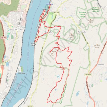
Interactive trail map

Gear up for your next adventure:

As an Amazon Associate, this site earns from qualifying purchases at no extra cost to you.

Trail profile

👉 Easily get elevation data in JSON, GeoTIFF and KML formats using Elevation API
Thank you for supporting this site ❤️
Make a donation

Gear up for your next adventure:

As an Amazon Associate, this site earns from qualifying purchases at no extra cost to you.

About this trail

Name: Hudson Highlands State Park - Canada Hill, White Rock, Sugarloaf Hill and Hudson River trail, distance, elevation, map, profile, GPS track

Start: Sugarloaf Trail, Glenclyffe, Town of Philipstown, Putnam County, New York, 10524, United States (41.37035 -73.94489)

End: 25, Wing and Wing Road, Glenclyffe, Town of Philipstown, Putnam County, New York, 10524, United States (41.37014 -73.94526)

Coordinates: 41.33851 -73.95587 41.37976 -73.93501

Topography: Putnam County topographic map, elevation, terrain

👉 Easily get elevation data in JSON, GeoTIFF and KML formats using Elevation API
Thank you for supporting this site ❤️
Make a donation

Gear up for your next adventure:

As an Amazon Associate, this site earns from qualifying purchases at no extra cost to you.

Other hiking, mountain biking, running and outdoor activity trails

Click on a trail to view its statistics, map and profile.

Montréal - New York

Canada > Quebec > Urban agglomeration of Montreal > Montreal

#Bike #Montréal #NewYork

Distance: 396.2 mi • Elevation gain: 15,945 ft • Maximum elevation: 988 ft