Make a donation
Gear up for your next adventure:
As an Amazon Associate, this site earns from qualifying purchases at no extra cost to you.
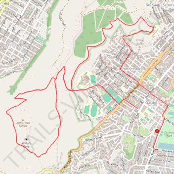
Signal Hill and Lions Head
- Distance: 6.9 mi
- Elevation gain: 1,545 ft
- Maximum elevation: 1,522 ft
- Elevation loss: 1,637 ft
- Minimum elevation: 167 ft
- Moving time: 1 h 43 m
- Moving speed: 4.0 mph
- Maximum speed: 12.5 mph
- Total time: 1 h 43 m
- Global speed: 4.0 mph
Interactive trail map
Make a donation
Gear up for your next adventure:
As an Amazon Associate, this site earns from qualifying purchases at no extra cost to you.
Trail profile
- Distance: 6.9 mi
- Elevation gain: 1,545 ft
- Maximum elevation: 1,522 ft
- Elevation loss: 1,637 ft
- Minimum elevation: 167 ft
- Moving time: 1 h 43 m
- Moving speed: 4.0 mph
- Maximum speed: 12.5 mph
- Total time: 1 h 43 m
- Global speed: 4.0 mph
Make a donation
Gear up for your next adventure:
As an Amazon Associate, this site earns from qualifying purchases at no extra cost to you.
About this trail
Name: Signal Hill and Lions Head trail, distance, elevation, map, profile, GPS track
Coordinates: -33.93996 18.38658 -33.92154 18.41207
Make a donation
Gear up for your next adventure:
As an Amazon Associate, this site earns from qualifying purchases at no extra cost to you.
Other hiking, mountain biking, running and outdoor activity trails
Click on a trail to view its statistics, map and profile.
Simon's Town - Cape Town
South Africa > Western Cape > City of Cape Town > Simon's Town
#Bike
Distance: 33.5 mi • Elevation gain: 3,698 ft • Maximum elevation: 604 ft
Cape Town - Gun Run Trail 2023
South Africa > Western Cape > City of Cape Town > Cape Town
Distance: 10.8 mi • Elevation gain: 2,329 ft • Maximum elevation: 1,709 ft