Make a donation
Gear up for your next adventure:
As an Amazon Associate, this site earns from qualifying purchases at no extra cost to you.
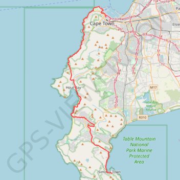
Simon's Town - Cape Town
#Bike
- Distance: 33.5 mi
- Elevation gain: 3,698 ft
- Maximum elevation: 604 ft
- Elevation loss: 3,881 ft
- Minimum elevation: 3 ft
Interactive trail map
Make a donation
Gear up for your next adventure:
As an Amazon Associate, this site earns from qualifying purchases at no extra cost to you.
Trail profile
- Distance: 33.5 mi
- Elevation gain: 3,698 ft
- Maximum elevation: 604 ft
- Elevation loss: 3,881 ft
- Minimum elevation: 3 ft
Make a donation
Gear up for your next adventure:
As an Amazon Associate, this site earns from qualifying purchases at no extra cost to you.
About this trail
Name: Simon's Town - Cape Town trail, distance, elevation, map, profile, GPS track
Coordinates: -34.19589 18.34376 -33.89950 18.43897
Make a donation
Gear up for your next adventure:
As an Amazon Associate, this site earns from qualifying purchases at no extra cost to you.
Other hiking, mountain biking, running and outdoor activity trails
Click on a trail to view its statistics, map and profile.
Table Mountain traverse from Kloof Corner to Suikerbossie via Maclear's Beacon
South Africa > Western Cape > City of Cape Town > Cape Town
Distance: 12.9 mi • Elevation gain: 4,957 ft • Maximum elevation: 3,533 ft
Make a donation
Gear up for your next adventure:
As an Amazon Associate, this site earns from qualifying purchases at no extra cost to you.
Klein-Tuinkop Loop Trail in Cape Floral Region Protected Areas
South Africa > Western Cape > City of Cape Town
Distance: 4.6 mi • Elevation gain: 1,132 ft • Maximum elevation: 1,565 ft
High Steenberg via Wolfkop
South Africa > Western Cape > City of Cape Town
This relatively easy hike begins with a short but steep, unexposed scramble up to Wolfkop. From there, you follow a circular route that takes you past Steenberg Peak with panoramic views of the surrounding mountains, valleys, and the coastline in the distance.
Distance: 2.2 mi • Elevation gain: 791 ft • Maximum elevation: 1,755 ft
Route von Longmarket Street nach/zu Rhodesrylaan
South Africa > Western Cape > City of Cape Town > Cape Town
Distance: 7.7 mi • Elevation gain: 489 ft • Maximum elevation: 374 ft
Make a donation
Gear up for your next adventure:
As an Amazon Associate, this site earns from qualifying purchases at no extra cost to you.
Signal Hill and Lions Head
South Africa > Western Cape > City of Cape Town > Cape Town
Distance: 6.9 mi • Elevation gain: 1,545 ft • Maximum elevation: 1,522 ft
Cape Town - Gun Run Trail 2023
South Africa > Western Cape > City of Cape Town > Cape Town
Distance: 10.8 mi • Elevation gain: 2,329 ft • Maximum elevation: 1,709 ft