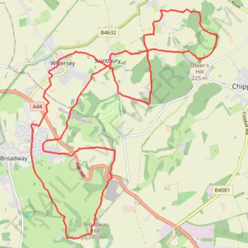
Dover's Hill and Broadway Hill loop trailrun
- Distance: 13.7 mi
- Elevation gain: 1,867 ft
- Maximum elevation: 1,030 ft
- Elevation loss: 1,870 ft
- Minimum elevation: 256 ft
- Moving time: 2 h 24 m
- Moving speed: 5.7 mph
- Maximum speed: 10.8 mph
- Total time: 2 h 27 m
- Global speed: 5.6 mph
Interactive trail map
Trail profile
- Distance: 13.7 mi
- Elevation gain: 1,867 ft
- Maximum elevation: 1,030 ft
- Elevation loss: 1,870 ft
- Minimum elevation: 256 ft
- Moving time: 2 h 24 m
- Moving speed: 5.7 mph
- Maximum speed: 10.8 mph
- Total time: 2 h 27 m
- Global speed: 5.6 mph
About this trail
Name: Dover's Hill and Broadway Hill loop trailrun trail, distance, elevation, map, profile, GPS track
Coordinates: 52.01938 -1.85630 52.06490 -1.79636
Other hiking, mountain biking, running and outdoor activity trails
Click on a trail to view its statistics, map and profile.
Dover's Hill - Bretforton - Honeybourne - Dover's Hill
United Kingdom > England > Gloucestershire > Cotswold District
Distance: 11.8 mi • Elevation gain: 771 ft • Maximum elevation: 735 ft
Broadway ↗️ Snowshill ↘️ Stanton ➡️ Buckland
United Kingdom > England > Worcestershire > Wychavon > Broadway
Distance: 14.1 mi • Elevation gain: 2,316 ft • Maximum elevation: 1,056 ft