Broadway ↗️ Snowshill ↘️ Stanton ➡️ Buckland
- Distance: 14.1 mi
- Elevation gain: 2,316 ft
- Maximum elevation: 1,056 ft
- Elevation loss: 2,313 ft
- Minimum elevation: 272 ft
- Moving time: 2 h 35 m
- Moving speed: 5.4 mph
- Maximum speed: 11.9 mph
- Total time: 2 h 35 m
- Global speed: 5.4 mph
Interactive trail map
Trail profile
- Distance: 14.1 mi
- Elevation gain: 2,316 ft
- Maximum elevation: 1,056 ft
- Elevation loss: 2,313 ft
- Minimum elevation: 272 ft
- Moving time: 2 h 35 m
- Moving speed: 5.4 mph
- Maximum speed: 11.9 mph
- Total time: 2 h 35 m
- Global speed: 5.4 mph
About this trail
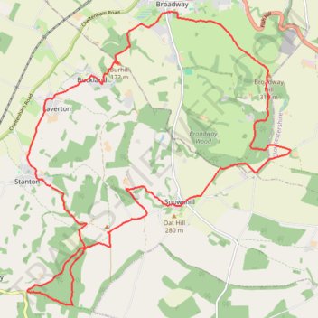
Name: Broadway ↗️ Snowshill ↘️ Stanton ➡️ Buckland trail, distance, elevation, map, profile, GPS track
Coordinates: 51.98456 -1.90144 52.03399 -1.82926
Other hiking, mountain biking, running and outdoor activity trails
Click on a trail to view its statistics, map and profile.
Blockley 🔁 Snowshill
United Kingdom > England > Gloucestershire > Cotswold District > Blockley
Blockley-Snowshill loop trailrun
Distance: 15.5 mi • Elevation gain: 1,640 ft • Maximum elevation: 1,040 ft
Broadway ➡️ Wood Stanway ➡️ Cutsdean ➡️ Broadway
United Kingdom > England > Worcestershire > Wychavon > Broadway
Distance: 15.2 mi • Elevation gain: 1,985 ft • Maximum elevation: 997 ft
Dover's Hill and Broadway Hill loop trailrun
United Kingdom > England > Gloucestershire > Cotswold District
Distance: 13.7 mi • Elevation gain: 1,867 ft • Maximum elevation: 1,030 ft