Make a donation
Gear up for your next adventure:
As an Amazon Associate, this site earns from qualifying purchases at no extra cost to you.
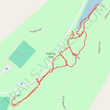
Gedney Park Central
- Distance: 1.2 mi
- Elevation gain: 85 ft
- Maximum elevation: 440 ft
- Elevation loss: 85 ft
- Minimum elevation: 397 ft
- Moving time: 33 m 15 s
- Moving speed: 2.1 mph
- Maximum speed: 4.4 mph
- Total time: 44 m 22 s
- Global speed: 1.6 mph
Interactive trail map
Make a donation
Gear up for your next adventure:
As an Amazon Associate, this site earns from qualifying purchases at no extra cost to you.
Trail profile
- Distance: 1.2 mi
- Elevation gain: 85 ft
- Maximum elevation: 440 ft
- Elevation loss: 85 ft
- Minimum elevation: 397 ft
- Moving time: 33 m 15 s
- Moving speed: 2.1 mph
- Maximum speed: 4.4 mph
- Total time: 44 m 22 s
- Global speed: 1.6 mph
Make a donation
Gear up for your next adventure:
As an Amazon Associate, this site earns from qualifying purchases at no extra cost to you.
About this trail
Name: Gedney Park Central trail, distance, elevation, map, profile, GPS track
Coordinates: 41.18234 -73.79810 41.18647 -73.79339
Topography: Westchester County topographic map, elevation, terrain
Make a donation
Gear up for your next adventure:
As an Amazon Associate, this site earns from qualifying purchases at no extra cost to you.
Other hiking, mountain biking, running and outdoor activity trails
Click on a trail to view its statistics, map and profile.
Gedney Park East
United States > New York > Westchester County > Millwood
Distance: 2.0 mi • Elevation gain: 174 ft • Maximum elevation: 479 ft
Gedney Park West
United States > New York > Westchester County > Millwood
Distance: 2.4 mi • Elevation gain: 390 ft • Maximum elevation: 558 ft