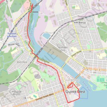
Walk - Trent River
Canada, ON, Trenton Quinte West
- Distance: 3.4 mi
- Elevation gain: 85 ft
- Maximum elevation: 282 ft
- Elevation loss: 82 ft
- Minimum elevation: 243 ft
- Moving time: 1 h 18 m
- Moving speed: 2.6 mph
- Maximum speed: 3.3 mph
- Total time: 1 h 38 m
- Global speed: 2.1 mph
Interactive trail map
Trail profile
- Distance: 3.4 mi
- Elevation gain: 85 ft
- Maximum elevation: 282 ft
- Elevation loss: 82 ft
- Minimum elevation: 243 ft
- Moving time: 1 h 18 m
- Moving speed: 2.6 mph
- Maximum speed: 3.3 mph
- Total time: 1 h 38 m
- Global speed: 2.1 mph
About this trail
Name: Walk - Trent River trail, distance, elevation, map, profile, GPS track
Coordinates: 44.09565 -77.59303 44.12253 -77.57330
Other hiking, mountain biking, running and outdoor activity trails
Click on a trail to view its statistics, map and profile.
Cobourg - Belleville
Canada > Ontario > Northumberland County > Cobourg
#Bike
Distance: 50.6 mi • Elevation gain: 938 ft • Maximum elevation: 387 ft