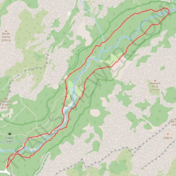
Mirror Lake and Valley Loop Trail in Yosemite National Park
The Mirror Lake and Valley Loop Trail in Yosemite National Park offers hikers stunning views of Tenaya Canyon, Mount Watkins, and the Washington Column, all beneath the iconic Half Dome. This relatively easy trail winds through lush forests and along the tranquil Tenaya Creek, leading to Mirror Lake, which reflects the surrounding granite cliffs when water levels are high. Hikers can enjoy the peaceful ambiance of the area, with towering cliff faces and shaded paths framed by lush greenery, offering the possibility of spotting local wildlife. #Hiking #Loop #Mountain #Canyon #River #Lake #Yosemite #Nature #Cliff
- Distance: 4.5 mi
- Elevation gain: 443 ft
- Maximum elevation: 4,190 ft
- Elevation loss: 443 ft
- Minimum elevation: 4,003 ft
- Moving time: 1 h 41 m
- Moving speed: 2.7 mph
- Maximum speed: 6.0 mph
- Total time: 1 h 55 m
- Global speed: 2.4 mph
Interactive trail map
Trail profile
- Distance: 4.5 mi
- Elevation gain: 443 ft
- Maximum elevation: 4,190 ft
- Elevation loss: 443 ft
- Minimum elevation: 4,003 ft
- Moving time: 1 h 41 m
- Moving speed: 2.7 mph
- Maximum speed: 6.0 mph
- Total time: 1 h 55 m
- Global speed: 2.4 mph
About this trail
Name: Mirror Lake and Valley Loop Trail in Yosemite National Park trail, distance, elevation, map, profile, GPS track
Start: Curry Village, Mariposa County, California, United States (37.73989 -119.55979)
End: Curry Village, Mariposa County, California, United States (37.73983 -119.55977)
Coordinates: 37.73983 -119.55979 37.75975 -119.53431
Topography: Mariposa County topographic map, elevation, terrain
Other hiking, mountain biking, running and outdoor activity trails
Click on a trail to view its statistics, map and profile.
Half Dome
United States > California > Mariposa County > Curry Village
From Happy Isles, this demanding Yosemite route follows the Merced River into the forested canyon of the Mist Trail, passing the spray and granite stairways of Vernal Fall before continuing above the river toward Emerald Pool and the broader waterfall amphitheater around Nevada Fall. Beyond Nevada Fall, the…
Distance: 15.4 mi • Elevation gain: 6,506 ft • Maximum elevation: 8,816 ft
Half Dome via John Muir Trail and Vernal Fall in Yosemite National Park
United States > California > Mariposa County > Curry Village
The Half Dome hike is a true Yosemite adventure. With breathtaking views of the falls, Yosemite Valley, and the Sierra Nevada, it rewards those who tackle its challenging terrain. The final ascent up the cable route is thrilling, and while demanding, it’s an unforgettable experience that’s well worth the…
Distance: 16.3 mi • Elevation gain: 6,368 ft • Maximum elevation: 8,816 ft
Half Dome via Vernal and Nevada Falls
United States > California > Mariposa County > Curry Village
Starting near Happy Isles in eastern Yosemite Valley, this route follows the Merced River into the Mist Trail corridor, with early granite scenery and possible views toward Illilouette Fall before reaching the Vernal Fall Footbridge. The ascent then climbs beside Vernal Fall to Emerald Pool and Silver Apron,…
Distance: 16.6 mi • Elevation gain: 6,739 ft • Maximum elevation: 8,835 ft
Mirror Lake Trail in Yosemite National Park
United States > California > Mariposa County > Curry Village
The Mirror Lake Trail in Yosemite National Park offers a peaceful hike through Tenaya Canyon, framed by dramatic granite cliffs like Half Dome and North Dome. The trail winds alongside Tenaya Creek, providing a serene experience with forested sections, sandy riverbeds, and seasonal reflections in the lake,…
Distance: 2.8 mi • Elevation gain: 230 ft • Maximum elevation: 4,124 ft
Yosemite North Dome Loop
United States > California > Mariposa County > Curry Village
Loop hike to North Dome via Lower Mirror Lake, Tenaya Creek, Valley Loop Trail, Snow Creek Trail, North Dome Trail, Upper Yosemite Fall Trail, Oh My Gosh Point and Columbia Rock in the Yosemite National Park. #Hiking #Loop #Mountain #Nature #Lake #Forest #Fall #Park #Yosemite
Distance: 19.9 mi • Elevation gain: 7,464 ft • Maximum elevation: 8,150 ft