Make a donation
Gear up for your next adventure:
As an Amazon Associate, this site earns from qualifying purchases at no extra cost to you.
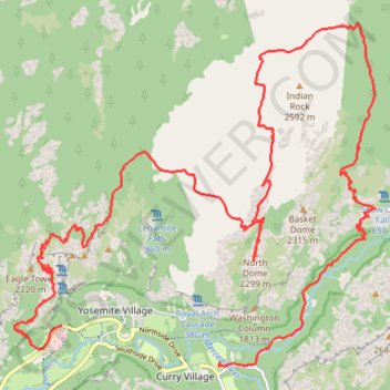
Yosemite North Dome Loop
Loop hike to North Dome via Lower Mirror Lake, Tenaya Creek, Valley Loop Trail, Snow Creek Trail, North Dome Trail, Upper Yosemite Fall Trail, Oh My Gosh Point and Columbia Rock in the Yosemite National Park. #Hiking #Loop #Mountain #Nature #Lake #Forest #Fall #Park #Yosemite
- Distance: 19.9 mi
- Elevation gain: 7,464 ft
- Maximum elevation: 8,150 ft
- Elevation loss: 7,477 ft
- Minimum elevation: 3,996 ft
- Moving time: 12 h 42 m
- Moving speed: 1.6 mph
- Maximum speed: 16.7 mph
- Total time: 15 h 2 m
- Global speed: 1.3 mph
Interactive trail map
Make a donation
Gear up for your next adventure:
As an Amazon Associate, this site earns from qualifying purchases at no extra cost to you.
Trail profile
- Distance: 19.9 mi
- Elevation gain: 7,464 ft
- Maximum elevation: 8,150 ft
- Elevation loss: 7,477 ft
- Minimum elevation: 3,996 ft
- Moving time: 12 h 42 m
- Moving speed: 1.6 mph
- Maximum speed: 16.7 mph
- Total time: 15 h 2 m
- Global speed: 1.3 mph
Make a donation
Gear up for your next adventure:
As an Amazon Associate, this site earns from qualifying purchases at no extra cost to you.
About this trail
Name: Yosemite North Dome Loop trail, distance, elevation, map, profile, GPS track
Coordinates: 37.73941 -119.60638 37.79194 -119.53662
Topography: Mariposa County topographic map, elevation, terrain
Make a donation
Gear up for your next adventure:
As an Amazon Associate, this site earns from qualifying purchases at no extra cost to you.
Other hiking, mountain biking, running and outdoor activity trails
Click on a trail to view its statistics, map and profile.
Half Dome
United States > California > Mariposa County > Curry Village
From Happy Isles, this demanding Yosemite route follows the Merced River into the forested canyon of the Mist Trail, passing the spray and granite stairways of Vernal Fall before continuing above the river toward Emerald Pool and the broader waterfall amphitheater around Nevada Fall. Beyond Nevada Fall, the…
Distance: 15.4 mi • Elevation gain: 6,506 ft • Maximum elevation: 8,816 ft
Upper Yosemite Fall, Yosemite Point, Oh My Gosh Point and Columbia Rock
United States > California > Mariposa County > Yosemite Village > Yosemite Lodge
Starting near Yosemite Lodge and the Camp Four area, this demanding route climbs the Upper Yosemite Fall Trail through oak woodland and granite switchbacks, quickly rising above Yosemite Valley toward Columbia Rock, where broad views open over the valley floor, Merced River corridor, Half Dome, and surrounding…
Distance: 9.3 mi • Elevation gain: 7,995 ft • Maximum elevation: 7,031 ft
Half Dome via John Muir Trail and Vernal Fall in Yosemite National Park
United States > California > Mariposa County > Curry Village
The Half Dome hike is a true Yosemite adventure. With breathtaking views of the falls, Yosemite Valley, and the Sierra Nevada, it rewards those who tackle its challenging terrain. The final ascent up the cable route is thrilling, and while demanding, it’s an unforgettable experience that’s well worth the…
Distance: 16.3 mi • Elevation gain: 6,368 ft • Maximum elevation: 8,816 ft
Columbia Rock
United States > California > Mariposa County > Yosemite Village > Yosemite Lodge
From the Yosemite Valley near Camp Four, the Upper Yosemite Fall Trail climbs steadily into the forest, following a long series of switchbacks above the valley floor. The route reaches Columbia Rock, a rocky overlook with a broad panorama over Yosemite Valley, Half Dome, Sentinel Rock and the surrounding…
Distance: 1.0 mi • Elevation gain: 1,171 ft • Maximum elevation: 5,023 ft
Make a donation
Gear up for your next adventure:
As an Amazon Associate, this site earns from qualifying purchases at no extra cost to you.
Lower Yosemite Fall and Cook's Meadow Trails Loop
United States > California > Mariposa County > Yosemite Village > Yosemite Lodge
Starting near Yosemite Valley Lodge, the route enters the Lower Yosemite Fall Trail, follows Yosemite Creek through shaded valley woodland, and reaches the footbridge and close viewpoint beneath Lower Yosemite Fall. It then returns toward Northside Drive and crosses into Cook’s Meadow, where open meadow…
Distance: 2.0 mi • Elevation gain: 246 ft • Maximum elevation: 4,108 ft
Upper Yosemite Fall Trail via Columbia Rock and Oh My Gosh Point
United States > California > Mariposa County > Yosemite Lodge
The Upper Yosemite Fall Trail is a rewarding yet challenging hike that offers some of the best panoramic views in Yosemite National Park. Climbing steep switchbacks, you'll pass Columbia Rock for breathtaking sights of Yosemite Valley and continue toward Oh My Gosh Point, where the dramatic view of the falls…
Distance: 7.4 mi • Elevation gain: 4,902 ft • Maximum elevation: 6,693 ft
Yosemite Valley Loop
United States > California > Mariposa County > Yosemite Village
From Yosemite Village, the route slips into the Valley Loop Trail corridor, moving through the quieter village edge toward Yosemite Falls views before continuing west below the Three Brothers and into the open floor of Leidig Meadow, where forest, meadow grass, and the Merced River alternate along the way. The…
Distance: 9.2 mi • Elevation gain: 699 ft • Maximum elevation: 4,068 ft
Mirror Lake Trail in Yosemite National Park
United States > California > Mariposa County > Curry Village
The Mirror Lake Trail in Yosemite National Park offers a peaceful hike through Tenaya Canyon, framed by dramatic granite cliffs like Half Dome and North Dome. The trail winds alongside Tenaya Creek, providing a serene experience with forested sections, sandy riverbeds, and seasonal reflections in the lake,…
Distance: 2.8 mi • Elevation gain: 230 ft • Maximum elevation: 4,124 ft
Make a donation
Gear up for your next adventure:
As an Amazon Associate, this site earns from qualifying purchases at no extra cost to you.
Mirror Lake and Valley Loop Trail in Yosemite National Park
United States > California > Mariposa County > Curry Village
The Mirror Lake and Valley Loop Trail in Yosemite National Park offers hikers stunning views of Tenaya Canyon, Mount Watkins, and the Washington Column, all beneath the iconic Half Dome. This relatively easy trail winds through lush forests and along the tranquil Tenaya Creek, leading to Mirror Lake, which…
Distance: 4.5 mi • Elevation gain: 443 ft • Maximum elevation: 4,190 ft
Columbia Rock Trail via Upper Yosemite Fall Trail in Yosemite National Park
United States > California > Mariposa County > Yosemite Village > Yosemite Lodge
The Columbia Rock Trail, accessible via the Upper Yosemite Fall Trail, offers hikers a rewarding ascent through oak woodlands and granite switchbacks. Upon reaching Columbia Rock, you're greeted with panoramic views of Yosemite Valley, including iconic landmarks like Half Dome and Sentinel Rock. For those…
Distance: 1.9 mi • Elevation gain: 1,211 ft • Maximum elevation: 5,023 ft
Lower Yosemite Fall Trail and Cook's Meadow Trail Loop in Yosemite National Park
United States > California > Mariposa County > Yosemite Village > Yosemite Lodge
The combined Lower Yosemite Fall and Cook's Meadow Trails Loop in Yosemite National Park offer hikers breathtaking views of iconic landmarks. Along this easy, flat path, you'll encounter stunning vistas of Yosemite Falls, Half Dome, Sentinel Rock, and Glacier Point, all set against the serene backdrop of lush…
Distance: 2.0 mi • Elevation gain: 240 ft • Maximum elevation: 4,104 ft
Yosemite Point via Upper Yosemite Fall Trail in Yosemite National Park
United States > California > Mariposa County > Yosemite Lodge
The Upper Yosemite Falls Trail to Yosemite Point is a strenuous hike that offers hikers panoramic views of Yosemite Valley, including iconic landmarks such as Half Dome and the Cathedral Spires. Along the ascent, the trail provides close-up perspectives of the majestic Upper Yosemite Falls—one of the tallest…
Distance: 8.6 mi • Elevation gain: 5,823 ft • Maximum elevation: 7,014 ft
Make a donation
Gear up for your next adventure:
As an Amazon Associate, this site earns from qualifying purchases at no extra cost to you.
Upper Yosemite Fall Trail in Yosemite National Park
United States > California > Mariposa County > Yosemite Village > Yosemite Lodge
The Upper Yosemite Fall Trail is a demanding hike that rewards adventurers with breathtaking panoramic views of Yosemite Valley, Half Dome, and the mighty Yosemite Falls. As you ascend, you'll pass through diverse terrain, from oak forests and steep switchbacks to open sections offering sweeping vistas. The…
Distance: 6.3 mi • Elevation gain: 4,925 ft • Maximum elevation: 6,690 ft
Lower Yosemite Falls Trail in Yosemite National Park
United States > California > Mariposa County > Yosemite Village > Yosemite Lodge
Hiking the Lower Yosemite Falls Trail is a delightful experience for nature lovers of all ages! The paved path makes it accessible, and the breathtaking views of the waterfalls are especially spectacular in spring when the snowmelt creates a powerful flow. Plus, you can enjoy the tranquility of the surrounding…
Distance: 1.4 mi • Elevation gain: 197 ft • Maximum elevation: 4,101 ft
Make a donation
Gear up for your next adventure:
As an Amazon Associate, this site earns from qualifying purchases at no extra cost to you.
Make a donation
Gear up for your next adventure:
As an Amazon Associate, this site earns from qualifying purchases at no extra cost to you.