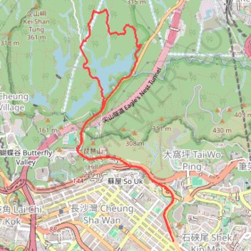
走私坳南坑
- Distance: 6.1 mi
- Elevation gain: 1,191 ft
- Maximum elevation: 820 ft
- Elevation loss: 1,168 ft
- Minimum elevation: 36 ft
- Moving time: 1 h 38 m
- Moving speed: 3.7 mph
- Maximum speed: 9.4 mph
- Total time: 1 h 46 m
- Global speed: 3.4 mph
Interactive trail map
Trail profile
- Distance: 6.1 mi
- Elevation gain: 1,191 ft
- Maximum elevation: 820 ft
- Elevation loss: 1,168 ft
- Minimum elevation: 36 ft
- Moving time: 1 h 38 m
- Moving speed: 3.7 mph
- Maximum speed: 9.4 mph
- Total time: 1 h 46 m
- Global speed: 3.4 mph
About this trail
Name: 走私坳南坑 trail, distance, elevation, map, profile, GPS track
Coordinates: 22.33371 114.15056 22.36174 114.16308
Other hiking, mountain biking, running and outdoor activity trails
Click on a trail to view its statistics, map and profile.
Golden Hill Path
China > Hong Kong > Kwai Tsing District > Kwai Chung > Shek Lei Hill Village
Distance: 6.6 mi • Elevation gain: 2,093 ft • Maximum elevation: 997 ft
城門~北潭坳
China > Hong Kong > Tsuen Wan District > Kwai Chung > Lower Shing Mun Village
ShingMunReservoir~PakTamAu
Distance: 23.3 mi • Elevation gain: 7,156 ft • Maximum elevation: 1,808 ft
Wilson Trail Full Route
China > Hong Kong > Hong Kong Island
Distance: 50.5 mi • Elevation gain: 14,534 ft • Maximum elevation: 2,011 ft
麦理浩径
China > Hong Kong > Sai Kung District > Tsak Yue Wu
北潭涌至屯门
Distance: 61.3 mi • Elevation gain: 16,886 ft • Maximum elevation: 3,031 ft