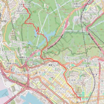
白雲澗 金山坑右澗
- Distance: 5.3 mi
- Elevation gain: 1,401 ft
- Maximum elevation: 1,056 ft
- Elevation loss: 1,184 ft
- Minimum elevation: 33 ft
- Moving time: 2 h 7 m
- Moving speed: 2.5 mph
- Maximum speed: 7.1 mph
- Total time: 2 h 40 m
- Global speed: 2.0 mph
Interactive trail map
Trail profile
- Distance: 5.3 mi
- Elevation gain: 1,401 ft
- Maximum elevation: 1,056 ft
- Elevation loss: 1,184 ft
- Minimum elevation: 33 ft
- Moving time: 2 h 7 m
- Moving speed: 2.5 mph
- Maximum speed: 7.1 mph
- Total time: 2 h 40 m
- Global speed: 2.0 mph
About this trail
Name: 白雲澗 金山坑右澗 trail, distance, elevation, map, profile, GPS track
Coordinates: 22.32534 114.14228 22.36830 114.17010
Other hiking, mountain biking, running and outdoor activity trails
Click on a trail to view its statistics, map and profile.
Golden Hill Path
China > Hong Kong > Kwai Tsing District > Kwai Chung > Shek Lei Hill Village
Distance: 6.6 mi • Elevation gain: 2,093 ft • Maximum elevation: 997 ft
城門~北潭坳
China > Hong Kong > Tsuen Wan District > Kwai Chung > Lower Shing Mun Village
ShingMunReservoir~PakTamAu
Distance: 23.3 mi • Elevation gain: 7,156 ft • Maximum elevation: 1,808 ft
Lion Rock Country Park
China > Hong Kong > Sha Tin District > Tai Wai Village
Distance: 4.7 mi • Elevation gain: 1,243 ft • Maximum elevation: 538 ft
Wilson Trail Full Route
China > Hong Kong > Hong Kong Island
Distance: 50.5 mi • Elevation gain: 14,534 ft • Maximum elevation: 2,011 ft
石籬邨~火炭站
China > Hong Kong > Kwai Tsing District > Kwai Chung > Shek Lei Hang Village
Distance: 7.3 mi • Elevation gain: 2,405 ft • Maximum elevation: 1,572 ft
Over Beacon Hill
Distance: 5.7 mi • Elevation gain: 1,663 ft • Maximum elevation: 1,437 ft
麦理浩径
China > Hong Kong > Sai Kung District > Tsak Yue Wu
北潭涌至屯门
Distance: 61.3 mi • Elevation gain: 16,886 ft • Maximum elevation: 3,031 ft