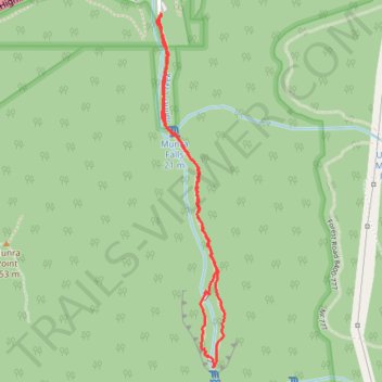
Wahclella Falls and Munra Falls
Via Wahclella Falls Trail in Columbia River Gorge National Scenic Area #Hiking #Waterfall #River #Gorge #Forest
- Distance: 1.9 mi
- Elevation gain: 741 ft
- Maximum elevation: 476 ft
- Elevation loss: 741 ft
- Minimum elevation: 95 ft
- Moving time: 52 m 9 s
- Moving speed: 2.2 mph
- Maximum speed: 5.3 mph
- Total time: 56 m 1 s
- Global speed: 2.0 mph
Interactive trail map
Trail profile
- Distance: 1.9 mi
- Elevation gain: 741 ft
- Maximum elevation: 476 ft
- Elevation loss: 741 ft
- Minimum elevation: 95 ft
- Moving time: 52 m 9 s
- Moving speed: 2.2 mph
- Maximum speed: 5.3 mph
- Total time: 56 m 1 s
- Global speed: 2.0 mph
About this trail
Name: Wahclella Falls and Munra Falls trail, distance, elevation, map, profile, GPS track
Coordinates: 45.61846 -121.95418 45.63033 -121.95087
Topography: Multnomah County topographic map, elevation, terrain
Other hiking, mountain biking, running and outdoor activity trails
Click on a trail to view its statistics, map and profile.
Wahclella Falls Trail in Columbia River Gorge National Scenic Area
United States > Oregon > Multnomah County > Bonneville
The Wahclella Falls Trail offers hikers a serene journey through the lush Columbia River Gorge. Along the path, you'll encounter the cascading Munra Falls, dense moss-covered forests, and the majestic two-tiered Wahclella Falls, which plunges into a tranquil pool surrounded by basalt cliffs. This picturesque…
Distance: 1.9 mi • Elevation gain: 807 ft • Maximum elevation: 495 ft
Wahclella Falls Trail in Columbia River Gorge National Scenic Area
United States > Oregon > Multnomah County > Bonneville
The Wahclella Falls Trail offers a serene, moderately challenging hike through a lush canyon. As you follow Tanner Creek, you'll pass smaller waterfalls like Munra Falls before arriving at the two-tiered Wahclella Falls, which cascades into a pool below. The trail is well-maintained, but some sections are…
Distance: 2.2 mi • Elevation gain: 1,083 ft • Maximum elevation: 486 ft
Northern part of the Pacific Crest Trail (PCT)
United States > Oregon > Klamath County
Hike on the Pacific Crest National Scenic Trail from Crater Lake to Canada Border through Oregon and Washington along the Sierra Nevada and Cascade mountain ranges. #Hiking #Mountain #SierraNevada #Cascade #Nature #Forest #Park #PCT
Distance: 744.6 mi • Elevation gain: 145,367 ft • Maximum elevation: 7,569 ft
Expedition to Sedum Ridge
United States > Oregon > Multnomah County > Portland
Distance: 133.4 mi • Elevation gain: 16,709 ft • Maximum elevation: 3,835 ft